“The answer is blowin’ in the wind.”
Bob Dylan, 1962
Bob Dylan, 1962
Nestled in an embayment at the foot of the Sangre de Cristo Mountains in south-central Colorado are the tallest sand dunes in North America, rising a staggering 750 feet above the flat terrain of the San Luis Valley. Although its shifting sands rejuvenate with the whim of the wind, the eolian dunefield remains transfixed in a perfect balance between the forces of nature that created it and those that want to cast it to the wind.
 |
| Darkened by light rain and shadows of the late day sun, the mineralogy of the dunefield’s darker sand hints at its provenance. |
The Great Sand Dunes are a spectacular example of what happens when topography such as mountains becomes involved in creating a wind-generated landform. When transported southwesterly-sand runs into the towering obstacle of the Sangre de Cristo’s, the shapes of the dunes within the field become more complex. Swirling northeasterly storm winds create a myriad of “complicated, merging ever-changing dune types” resulting in a “landscape of staggering complexity and beauty.” (Sand by Welland, 2009)
 |
| “Their appearance was exactly that of the sea in a storm, except as to color." Zebulon Pike of the Lewis and Clark Expedition First written account of the Great Sand Dunes in 1807 |
THE SAN LUIS VALLEY
In July, my colleague, geologist Wayne Ranney and I left the rugged San Juan Mountains in southwestern Colorado and headed east across the variably sun-parched and irrigation-quenched San Luis Valley. Our destination was Great Sand Dunes National Park and Preserve on the windward side of the Sangre de Cristo Mountains 65 miles to the east.
The intermontane valley resides within the embrace of the two mountain ranges, both of which belong to the Southern Rocky Mountains. Its a landscape of many contrasts. Vast dry regions with sparse, scrubby vegetation and alkali flats neighbor areas with saturated ground, thriving wetlands and lush crops, while ephemeral disappearing streams encircle vast sand dunes. The valley possesses both the driest and wettest parts of Colorado at the same time. Lying at an average altitude of 7,664 feet, it’s considered an arid high desert since it receives less than seven inches of rainfall a year.

But driving across its center, you wouldn’t suspect it. The valley is irrigated by a combination of surface water directed into a 150-mile system of canals and laterals, and by a rotating, mechanical army of pivot sprinklers fed by ten thousand artesian wells fed from aquifers located above and below a non-porous “Blue Clay Layer”, many at a mere 12 feet below the surface. The aquifers are replenished along the mountain fronts where water seeps into the recharge zone. The valley’s main crops include alfalfa, hay and potatoes, the United States’ second largest producer.

The San Luis Valley reminded me of the Imperial Valley in southern California, another arid region that combines water and sun into an agricultural oasis. Along with aquifers on the contemporary landscape, the Rio Grande and the other rivers that emanate from the mountain fronts flanking the valley have been the vital lifeline for civilization for thousands of years, just as it is today.

Approaching from the west, from a distance the dunes appear hazy and hauntingly mirage-like against the backdrop of the high peaks of the Sangre de Cristo’s. Early Native American travelers through the region, and later Spanish explorers, adventurous homesteaders, ranchers and farmers undoubtedly used the recognizable dunefield as a landmark, as did we. In fact, a network of ancient trails, the Los Caminos Antiguos, lives on as the modern highway on which we were driving.

A GEOLOGICAL SYSTEM IN PERFECT EQUILIBRIUM
The Great Sand Dunes geological system consists of four primary components: the dunefield (tucked into a mountain alcove); the sand sheet (the largest component of the system and the primary source of sand); the Sangre de Cristo Mountains (with its watershed and windshed); and the sabkha (to the west and south of the field where sand is seasonally saturated by rising ground water). The formation and preservation of the Great Sand Dunes is contingent on a unique balance that exists amongst its components.
 |
| From Valdez et al, 2006 |
THE SABKHA
In areas where the sand is seasonally saturated by rising ground water, a sabkha or salt-encrusted plain has developed, an Arabic landform. The geologic definition actually refers to a coastal setting characterized by evaporites and eolian deposits, but its usage is appropriate in this similar environment. In late summer when the water evaporates away, the dessicated minerals cement sand grains together forming a white crust of sodium carbonate, calcite and other evaporites. Early settlers collected the crust to use in baking or laundry detergent.
In this northeasterly Google Earth view, Great Sand Dunes rests against a backdrop of the Sangre de Cristo’s windward slope. Surrounded by the sand sheet, the fluctuating watertable and intermittent system of streams feed the ephemeral lakes and wetlands of the sabkha. Low-lying sabkha wetlands support a diverse ecosystem of shore and migratory birds, insects and reptiles.

THE SAND SHEET
Having nearly crossed the San Luis Valley, we’re looking back towards the distant San Juan Mountains. The verdant farmland we travelled through has become a dessicated, featureless plain called the “sand sheet.” We’re seeing it in its unirrigated, natural state. The natural vegetation consists mainly of phreatophytes and xerophytes, resistant plants that send water-seeking roots deep into the soil and plants that can tolerate dryness, respectively. The names of the plants sound just as hardy: greasewood, saltgrass, rabbitbrush and sagebrush.
The deepest portions of the sand sheet are thought to be the remnant of an ancient lake called Lake Alamosa, while its surface is wind-blown sand that is gradually moving toward the Great Sand Dunes, a vital clue to the dunefield’s genesis and replenishment.

Just south of the Great Sand Dunes, we’re standing on the edge of the sand sheet (red arrow on the map below shows the perspective of view), now a more dense grassland, and facing the Sangre de Cristo Mountain Range; the Culebra Range reaches to the south. Blanca Peak is the angular mountain hiding in the back, the fourth highest summit of the Rockies at 14,345 feet. Its namesake is derived from its light-colored, metamorphosed-Precambrian gneiss, which was driven upward as a crustal block along with the rest of the range.
Indicative of mountains of younger uplift, the massive alluvial slope is pouring off the mountain front and supports the lush Rio Grande National Forest. Due to strong meteorologic gradients the region contains ecozones ranging from Upper Sonoran on the valley floor to Alpine tundra above elevations of 12,500 feet. The Sangre de Cristo fault, a regional subset of the much larger Rio Grande fault, runs along the foot of the range. It became operational about 26 million years ago. Fault offsets within the alluvium that formed only a few thousand years ago indicate contemporary activity.
Indicative of mountains of younger uplift, the massive alluvial slope is pouring off the mountain front and supports the lush Rio Grande National Forest. Due to strong meteorologic gradients the region contains ecozones ranging from Upper Sonoran on the valley floor to Alpine tundra above elevations of 12,500 feet. The Sangre de Cristo fault, a regional subset of the much larger Rio Grande fault, runs along the foot of the range. It became operational about 26 million years ago. Fault offsets within the alluvium that formed only a few thousand years ago indicate contemporary activity.

Long before Spanish explorers arrived in the 1600’s, Stone Age hunters 11,000 years ago traversed the valley. Later, nomadic Clovis hunters and gatherers sought the large mammals such as mammoths and bison that grazed in the region, as did many Native American tribes. Discarded bones and projectile points scattered throughout the valley are evidence of their life-style especially in this fertile region.
The valley’s flatness is deceiving. Over 15,000 feet of clastic and volcanic sediments belie the fact that it is a heavily faulted-landscape, hinged downward an estimated four miles towards the Sangre de Cristo Mountains. The upper layers of valley fill are still horizontal, indicating that it was deposited during rifting and not before. The deeply buried Sangre de Cristo fault (red below) is a part of the larger Rio Grande fault system and runs along the foot of the range which stands as a remnant of the uplift. Notice the location of the Great Sand Dunes!
 |
| Modified from USGS |
THE GREAT SAND DUNES
Having fully crossed the valley, we made an arc around the sabkha and approached the Great Sand Dunes from the south. Too diminutive to be classified a sand sea or "erg", another Arabic landform, the dunefield is by no means small, consisting of almost 19,000 acres and measuring about 7 x 5 miles.
Although southerly to westerly winds dominate at the dunefield, subordinate northeasterly winds play a role in shaping the dunes. Unidirectional winds produce transverse dunes that migrate across the sandscape, whereas bimodal regimes produce sharply defined reversing dunes with foreset beds that dip in opposite directions. That gives them a “Chinese Wall” appearance at their crest, seen in the center of the photo, and contributes to their upward growth.
Three of the four components of its geological system are visible, juxtaposed in the photo: mountains, dunefield and sand sheet. How are these elements interrelated?

Great Sand Dunes appears today much as it did in 1873 when western photographer William Henry Jackson took this photo, although I took the liberty of adding a little faded color with Photoshop for effect. Our basic concept of sand dunes is that they migrate, yet from most early accounts and measurements the dunefield has changed little.
A comparison of the footprint of the dunefield over time indicates that it’s stationary while the shape and distribution of the dunes on the field is constantly changing with the whim of the wind. What forces of nature confine the dunes to a stable perimeter in a state of geological equilibrium?
A comparison of the footprint of the dunefield over time indicates that it’s stationary while the shape and distribution of the dunes on the field is constantly changing with the whim of the wind. What forces of nature confine the dunes to a stable perimeter in a state of geological equilibrium?
 |
| Courtesy of Park Ranger Patrick Myers of the Great Sand Dunes |
THE VIEW FROM WAY UP
The San Luis Valley is the Colorado member of a topographic depression called the San Luis Basin. Across the state line to the south, the New Mexican member is the Taos Plateau. The entire basin is the largest in the Southern Rocky Mountains at about 125 miles long and over 65 miles wide, about the size of Connecticut. It is flanked by the San Juan Mountains on the west and the Sangre de Cristo Mountains on the east, which converge at the basin’s northern edge.
Near La Garita Caldera in the San Juan Mountains, the Rio Grande River emerges from the eastern front and crosses the valley in a sweeping turn to the south. The green circles dotting the center of the basin are pivot sprinklers, and the circular isolated peaks further to the south are volcanoes of the San Luis Hills. On the east side of the valley, Great Sand Dunes is tucked into an alcove in the Sangre de Cristo’s western front (red arrow).
Does the dunefield’s locale and geographic relationships exist by geological accident or by tectonic design?
 |
| Google Earth |
THE EVOLUTION OF THE SANDSCAPE
How old are the Great Sand Dunes? How did it form? How did the dunes come to reside at the edge of this high, arid valley? What confines them to this location? Great Sand Dunes owes its existence to a number of conditions that involve climate, source of sand, means of transport and confinement, and accommodation space. Several hypotheses have been proposed for their origin and age. All agree that wind and water work in concert to form and replenish the dunefield, and that the dunefield is a young landform.
THE TECTONIC BIG PICTURE (one of many conceptual models)
The global tectonic setting of western North America has played a vital role in the genesis of the Great Sand Dunes. Seemingly unrelated events geographically far removed from the San Luis Valley conspired to create the dunefield in its unlikely or at least unexpected locale. It began with a change in the contemporary western margin of North America in the latest Jurassic, when its passive continental margin became an active, convergent plate boundary. The oceanic Farallon tectonic plate was beginning to subduct beneath the overriding North American plate.
The Farallon's descent initiated one continuous mountain-building event with two phases that overlapped in time and space called the Sevier and Laramide Orogenies. In the Late Cretaceous to the Paleocene (~80 to ~55 Ma), Laramide subduction geometry ("basement-cored") is considered responsible for the high-relief landscape of the Rocky Mountains and the uplift of the Colorado Plateau far inland of the tectonic collision zone.

SUBDUCTION HAS ITS CONSEQUENCES
The ultimate consumption and foundering of the Farallon coincides with compression that reverted to extension starting about 30 million years ago, manifested within the Basin and Range Province. In time, tensional forces and pull-apart landscapes not only surrounded the Colorado Plateau on three sides, but resulted in Oligocene through Miocene magmatism both within and along its boundary. The Rio Grande Rift on the eastern boundary of the Basin and Range Province represents its easternmost expression of extension. As we shall see, Oligocene magmatism and the subsequent formation of the rift will play a major role in the development of the Great Sand Dunes.
 |
| Modified from Wikipedia |
According to this flat-slab model, the consumption of the Farallon plate induced inflow of asthenospheric mantle that led to widespread melting of the lithosphere. Outside the eastern boundary of the Colorado Plateau, in response to Basin and Range extension and coinciding with extensional events and other volcanics that surround the Plateau, the pulse of magmatism generated volcanic eruptions during the Early Oligocene within the developing San Juan volcanic field.
 |
| Location of the Rio Grande Rift along the eastern edge of the Colorado Plateau in association with other Cenozoic volcanics Modified from Hopkins, 2002 |
The previously uplifted region of the San Juans proceeded to dome higher with volcanic activity. Commonly called the “ignimbrite flare-up,” massive volumes of viscous, gas-rich magmas emanated from about twenty caldera complexes in the San Juan field, the largest being La Garita. Such a tremendous volume of lava flows and ash was generated during the event that it was enough to cover Colorado with a blanket of rock a mile thick if it was deposited only across the state.
WHERE DID THE SAND IN THE GREAT SAND DUNES COME FROM?
Mineralogically, its sand is 28% quartz (the composition of most sand), 52% volcanic rock fragments (which explains the dark color of the sand) and 20% other minerals. Age studies of the sand indicate that 70% was derived from uppermost Eocene to Middle Miocene rocks (~35 to ~18 Ma) in the San Juan Mountains far to the west, while 30% originated from Paleoproterozoic (2500-1600 Ma) and Mesoproterozoic (1600-1000 Ma) core rocks of the Sangre de Cristo’s crystalline basement to the east. Thus, the dunefield’s predominant volcaniclastic composition is in keeping with a San Juan volcanic provenance.

HOW DID THE SAN LUIS BASIN AND VALLEY ORIGINATE EAST OF THE SAN JUAN'S?
The San Luis Basin (purple) is the most northerly (although a very small basin exists to its north) of a linear network of four north- to south-trending, asymmetric basins arranged en echelon (slightly overlapping and east or west stepping) that formed along the Rio Grande rift. The rift is a 250 km, tectonic-rent in the Earth’s crust from central Colorado through New Mexico into west Texas. It is one of the great rifts and valleys of the world, on a scale similar to the East African rift.
 |
| Modified image from USGS |
The Rio Grande Rift changed the landscape and geology of southern Colorado. Whether driven by gravitational collapse, active upwelling of a thermal plume, passively with buoyant mantle displacing the lithosphere or induced by a 1-1.5 degree clockwise rotation of the Colorado Plateau, the rift opened to the east and divided the land beginning about 26 Ma during the Oligocene. Tectonics was setting the stage for events that would ultimately form the Great Sand Dunes.
THE UPS AND DOWNS OF HORSTS AND GRABENS
As the landscape underwent east-west extension, the floor of the rift dropped downward and formed the aforementioned chain of basins. Called a half-graben (German for grave), the San Luis Basin hinged on the west at the San Juan Mountains and pivoted downward on the east along the Rio Grande Rift. That forced-upward a large crustal block called a horst (German for thicket) forming the Sangre de Cristo Mountains about 19 Ma.
The dropping of the grabens promoted extensive sedimentation from the flanking highlands. With a crustal thickness beneath the rift of 30 to 35 km, 10 to 15 km thinner than the Colorado Plateau on the west and the Great Plains to the east, crustal stretching and thinning produced basaltic magmatism within the rift zone. Each of the rift-basins has a more complex and differing structural morphology than that just described, but they share a common genesis as a consequence of the rift.
 |
| Down-on-the-east displacement of the San Luis Basin half-graben in response to extension (Modified from the Journal of Sedimentary Research) |
During the Pleistocene, the Rio Grande River drained the largest watershed of the San Juan Mountains. Thus began the movement of sand to the valley from meltwater runoff from its vast glaciers and snowfields. After exiting the range’s eastern front in the vicinity of the modern town of Del Norte, the river deposited an extensive alluvial fan (sandur) that prograded eastward into the valley.
 |
| From Madole et al, 2008 |
As the rift widened, the San Luis Basin subsided and the Sangre de Cristo’s rose up. Streams and sediments from both ranges flanking the basin eroded into the intervening valley forming a system of lakes whose extent was contingent on the climate. Today, most stream flow into the valley comes from the San Juans (~89%), whereas a lesser extent is from the Sangre de Cristo’s (~11%). It is assumed that the present water budget is somewhat reflective of the past.
PALEO-LAKE ALAMOSA AND THE ALAMOSA FORMATION
The largest body of water within the basin was Lake Alamosa that once covered the valley floor from Pliocene to middle Pleistocene time with alternating layers of sand, gravel and clay. It was one of the largest high-altitude lakes in North America measuring 105 by 48 km at its fullest extent. The paleo-lake expanded and contracted with changes in the climate that correlated with glacial and interglacial stages in the mountains, and gradually filled most of the paleo-valley with thousands of feet of the Alamosa Formation, which now floors the San Luis Valley.
 |
| Re-creation of Lake Alamosa from the San Luis Hills looking northeast at Blanca Peak in the Sangre de Cristo’s. Artist: Paco Van Sistine from Machette, 2007. |
The following geologic map of the San Luis Basin shows the stages in Lake Alamosa’s three million-year expansion and eventual demise from 3.5 to 3 Ma (A), 440,000 ka (B) to the present (C). During the middle Pleistocene about 440,000 years ago, Lake Alamosa overtopped a horst block of Oligocene volcanic rocks (of San Juan volcanic field affinities) at the Fairy Hills outlet (B) within the San Luis Hills and emptied to the south carving a gorge on its way to the Rio Grande River.
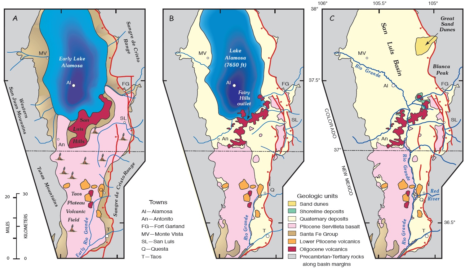 |
| A, Expansion of early Lake Alamosa; B, Lake Alamosa at its greatest expand before spillover; C, the basin of paleo-Lake Alamosa From Machette et al, 2007 |
WHAT ARE THE GEOLOGIC IMPLICATIONS OF LAKE ALAMOSA?
Its dry lakebed is thought to be the immediate (not the original!) source of eolian sand to the dunefield. In addition, the paleo-lake profoundly affected the evolution of the Rio Grande drainage system. With the draining of Lake Alamosa, the San Luis basin was the last of the four, closed rift-basins to be integrated into the developing Rio Grande watershed. Initially, the basins were closed and discrete on the floor of the rift but eventually became more or less continuous having been connected by through-going drainage of the river, ultimately with the emptying of Lake Alamosa.
We can clearly envision a “big picture” tectonic connection between the dunes, the rift, the valley and the two mountain ranges that comprise the Great Sand Dune's geological system. But, a few pieces of the geological puzzle are still missing!
LET'S REVIEW THE GEOLOGY OF THE VALLEY IN CROSS-SECTION
A contemporary, east-west cross-section of the San Luis Valley illustrates its down-on-the-east displacement within the Rio Grande rift, locally at the Sangre de Cristo fault. The valley's elevated topography is the site of repeated vertical tectonics including Proterozoic Yavapai, Pennsylvanian Ancestral Rocky Mountain and Late Cretaceous Laramide orogenesis. Its present topography, including its uplifted mountain flanks, are a direct expression of post-Oligocene displacement along normal faults of the rift.
The valley is an east-tilted, half-graben with a buried intra-horst that has divided the basin into two, second-order sub-basins, all of which lie beneath 15,000 feet of the aforementioned deposits. Flanked by the San Juan Mountains on the west and the uplifted horst-range of the Sangre de Cristo’s on the east, Lower and Middle Proterozoic igneous and metamorphic rocks form the basement of the valley. Overlying early Paleozoic rocks form a thin sequence of shelf clastics and carbonates, followed by coarse basin-clastics of the late Paleozoic Ancestral Rocky Mountains. Over that, the Oligocene Conejos Formation's (30-35 Ma) volcaniclastic flows and tuffs are derived from the San Juan volcanic field to the west.
The bulk of the basin fill is Miocene-Pliocene Santa Fe Formation’s sandy sediments. The uppermost valley fill is defined by the Quaternary Alamosa Formation’s alternating sands, silts and clays of mixed fluvial, lacustrine and eolian origin that reflects closed-basin deposition before the Rio Grande downstream had integrated with the San Luis Basin. Finally, Holocene deposition on the valley floor is a complex array of eolian (wind-related), alluvial (flowing water-related), paludal (marshy) and lacustrine (lake-related) deposits, and of course the sands of the Great Sand Dunes.
 |
| (From nps.gov) |
PREVAILING WESTERLIES PROVIDE A MEANS OF TRANSPORT
All deserts large or small share one thing - dryness. Arid regions cover 25% of our planet’s land surface. The major deserts of the world lie along the low latitudes both north and south of the equator within the zones of subtropical high pressure. The trade winds, having lost their moisture in the tropics, descend as dry masses of air and desiccate the land below. Interestingly, sand dunes actually cover only 20% of these arid regions.
Outside of the tropics in the middle latitudes between 30 and 60 degrees, arid landscapes occur where westerly global winds rise over mountain ranges, drop their load of moisture on windward-facing slopes, and descend on the eastern, leeward side forming rain shadow deserts. This is the circumstance across the San Luis Valley and at Great Sand Dunes (red dot) situated at 37.5º north latitude, where this mini-desert has formed from a “conspiracy of circumstances.”
 |
| From handsontheland.org |
Southwesterly winds from the San Juan Mountains are strong enough to carry sand on many days of the year toward the dunefield, but other factors are critical as well. Sparse vegetation and lack of binding cements exist which would otherwise inhibit transport and dry, loose sand to move. It is thought that the majority of eolian sand transport occurred during glacial times due to the availability of massive amounts of sand but has occurred episodically in post-Pleistocene, post-glacial times in smaller amounts.
The lowest part of the San Luis Basin beyond the alluvial fan of the Rio Grande is a nearly flat-floored depression referred to as "the sump." It is the depocenter for the alluvial fan and both ranges on opposing sides of the valley. The sump contains the immediate source of eolian sand in the Great Sand Dunes area, but is transported only when sand is "available", that is, free to move. The dry and mobile sands remain on the valley floor and are transported to the dunefield when conditions become favorable for eolian transport.
HOLOCENE WATER-TABLE FLUCTUATIONS
Likely beginning in the Middle Pleistocene and during contemporary Holocene time, the dunefield is the product of multiple episodes of sand transport that are controlled primarily by climatically-driven fluctuations of the water table near the surface. During times of greater precipitation, stream inflow from the surrounding mountains increased. As a result, more sediment was transported to the basin floor, the water table rose, and shallow lakes formed in some places. During megadroughts of the Holocene, water table in the basin fell, exposing sandy lake-floor sediment to wind erosion. A similar system of controls exists at the mountain front east of Great Sand Dunes.
RECYCLING WINDS AND WATERS
Most deserts are topographical depressions, largely surrounded by higher areas, and most of the sand remains in the desert confined by complex wind flow. The embayment at the foot of the Sangre de Cristo’s serves as the repository for the sand in transit from the sand sheet. Once transported, the sand is confined to its accommodation space by seasonal, summer storm winds (and diurnally from cold night air) that funnel through a large saddle in the range consisting of the three mountain passes: Music, Medano and Mosca. Opposing wind directions that converge on the dunefield are responsible for the dunes vertical growth.
 |
| From nps.gov |
Water from winter snowmelts and late summer monsoons also play a significant role in returning sand to the dunefield from the watershed of the Sangre de Cristo's. Two mountains streams, Medano and Sand Creeks, capture sand on the mountain side of the dunefield and carry it around the dunes back to the valley floor. The creeks disappear into the subsurface beneath the sand sheet and recharge the aquifers to the west of the dunefield, a distance of up to 10 kilometers. Eventually, the sand is returned to the dunefield by the prevailing southwesterlies. Geological poetry in motion!
HOW OLD ARE THE GREAT SAND DUNES?
The age of the Great Sand Dunes likely postdates the emptying of paleo-Lake Alamosa 440,000 years ago, when the first grain of sand began to tumble and bounce across the developing sand sheet, although the lake’s eastern shore likely was a very minor, early contributor. The formation of the dunefield likely predates the time when piedmont streams were deflected by eolian sand that accumulated near the foot of the Sangre de Cristo’s. Dating of the oldest alluvium of the deflected-reaches of these creeks has established that the dunefield began to form prior to 130,000 years ago. And of course, during the Holocene, the dunefield, although fully established, continues to evolve internally in concert with the wind and water regimes that contain it.
REPRISING THE ROLE OF TECTONICS
Rifting has created a closed-basin which allowed mobile sands to accumulate at the Great Sand Dunes. Rifting was also responsible for the development of the playa-lake system, the immediate source of the sand, and the configuration of the Sangre de Cristo Mountains, which provided the topographic controls on wind flow and whose streams define the perimeter of the dunefield and re-cycle its sands.
Far afield Farallon slab subduction is responsible for the formation and uplift of the Colorado Plateau and the ensuing extensional regime that gave birth to the San Juan volcanic center, the original source of the sand, and the Rio Grande Rift. Finally, we see how tectonics is responsible for the evolution of the ancient landscape that led to the formation of the Great Sand Dunes.
A personally inspiring and instructive quote from Lynn S. Fichter comes to mind, Professor of Stratigraphy and Paleontology in the Department of Geology and Environmental Studies at James Madison University in Harrisonburg, Virginia. He said “Plate tectonics is one of the great unifying theories in geology” and “Nothing in geology makes sense except in terms of plate tectonic theory.”
AN INVITATION
Please accompany me in my upcoming post Part II, when we climb the geology of the Great Sand Dunes. Also, check out Wayne Ranney's fantastic post on the Great Sand Dunes from our trip together here.
SUGGESTED READING
Ancient Landscapes of the Colorado Plateau by Ron Blakey and Wayne Ranney, 2008.
On the Origin and Age of the Great Sand Dunes, Colorado by Richard F. Madole et al, 2008.
Plateau – The Land and People of the Colorado Plateau by Wayne Ranney, Museum of Northern Arizona, 2009.
Sand – The Never Ending Story by Michael Welland, 2009.
The Geologic History of Colorado's Sangre de Cristo Range by David A. Lindsey, USGS 1349.
The Physics of Blown Sand and Desert Dunes by Ralph A. Bagnold, 1941.