Monday, December 31, 2012

2012 Geology Posts That Never Quite Made It

Puddingstones in Brookline, Massachusetts; Pleistocene Coral in the Bahamas; Dinosaurs Tracks in Connecticut; Monster Sea Scorpions in Upstate NY; Diatreme Volcanoes in New Mexico and Deadly Poisonous Mushrooms in Chestnut Hill, Massachusetts

Every blogger knows the challenge. What shall I blog about next? What photos should I use? By the time the end of the year rolls around, there are always a few posts that never quite made it. And so, with this final post of the year, here they are from here and there.


January
This massive, foot-long clast of Westboro Formation quartzite is embedded within an arkosic sandstone matrix of the Late Proterozoic Roxbury Conglomerate, one of two surficial rock units that comprise the Boston Basin. The Roxbury arrived in (better stated to have participated in the formation of) New England within the terrane of Avalonia, having rifted from the supercontinent of Gondwana in the middle latitudes of the southern hemisphere. Avalonia and its accompanying Roxbury made the tectonic journey across the closing Iapetus and Rheic seas during the Early to Middle Paleozoic. This puddingstone initiated my personal geological journey some twenty years ago.
Brookline, Massachusetts
February
A paper-thin veneer of new ice supports a bevy of gulls.
Chestnut Hill Reservoir, Newton, Massachusetts
March
Evidence for changing sea levels exists around the world including the Bahamas.
Low tide has exposed "shore rocks" along the island's north coast which are in reality
150,000 year old fossilized star, starlet and brain coral. This former patch reef was once covered by water considerably deeper during the last interglacial period. During the ensuing glacial period, the sea floor became exposed on land and covered by a limestone-derived soil. The crusty soil is eroding and can be seen on the coral, that is if you can take your eyes off the Caribbean's incredibly blue-green water.
Cable Beach, New Providence Island, Bahamas
March
This is a positive (upper member) cast of a portion of a trackway of a bipedal theropod
in shallow-water, arkosic sandstones of the Lower Jurassic Portland Formation. This brownstone, the building stone that shaped America during the late 1800's, was deposited in an aborted rift basin called the Hartford Basin in response to the opening of the Atlantic Ocean. The foot-long footprint is likely that of a Dilophosaurus or Coelophysis, early carnivors of the Mesozoic. Not too far from here in South Hadley, Massachusetts, in 1802 a farm boy named Pliny Moody discovered the first trackway in North America. That was in the Deerfield Basin, a failed rift basin almost identical stratigraphically to the Hartford. The local preacher, seeing the print's three-toed anatomy, called it Noah's Raven, a prophetic analysis considering the evolutionary relationship between reptiles and birds.
Meehan Quarry, Hartford Basin of the Connecticut Valley, Portland, Connecticut

March
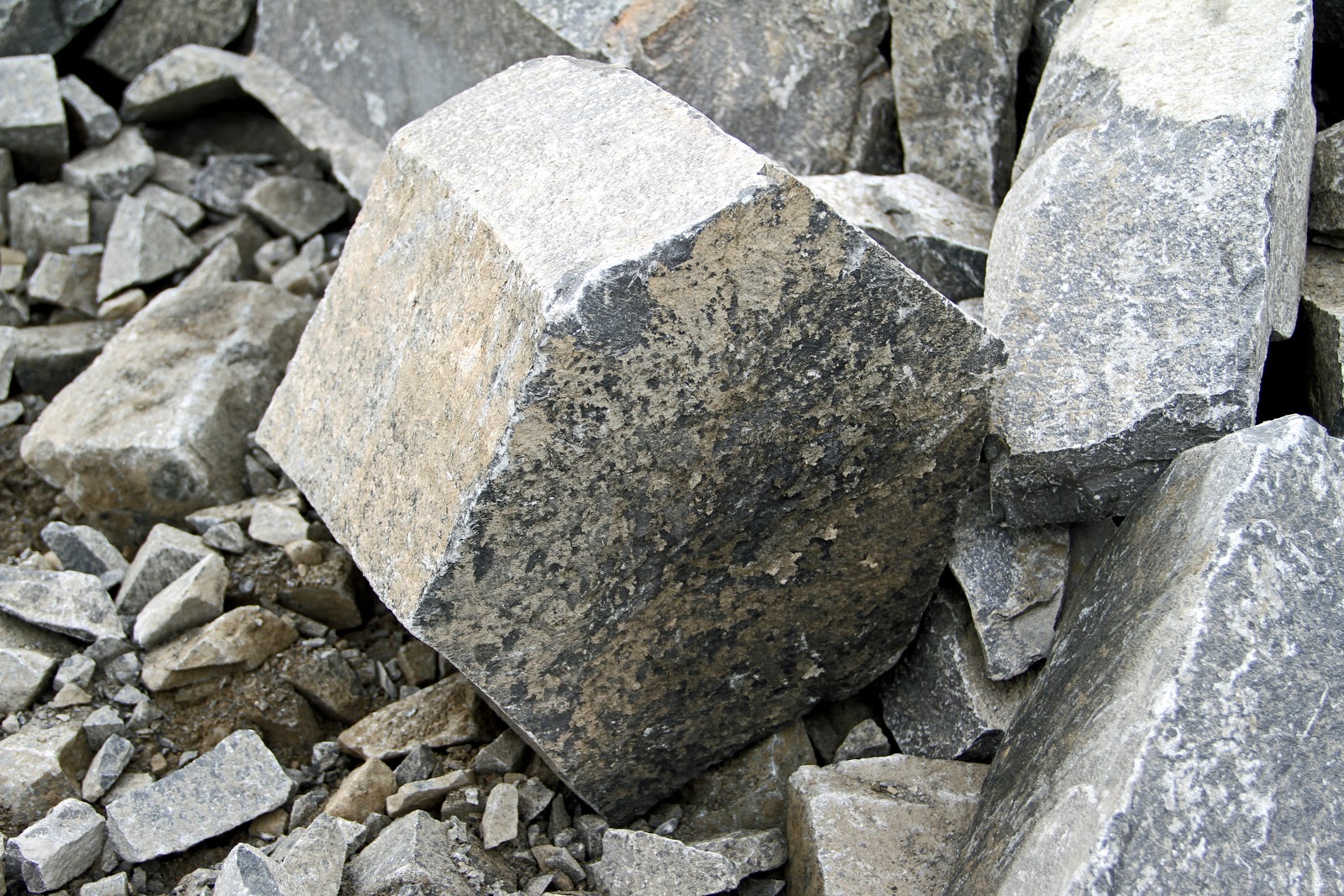
This hexagonal tholeiitic basalt, with its characteristic geometry of extremely regular polygonal joints,
formed as a consequence of its cooling history. These erratics fractured from a colonade of the Lower Jurassic Holyoke Basalt Flow, the middle of three flood basalts that were generated in 1,200 miles of Mesozoic rift basins along the eastern margin of North America (and across the Atlantic as well) during early rifting of the Atlantic Ocean. This trap rock, as it's called colloquially, has its name derived from the Swedish word for stairs ("trappa") referring to the step-like pattern the extrusive igneous rock assumes once cooled and contracted. Interestingly, the generation of massive volumes of this flood basalt is cited as a possible cause of the Permo-Triassic extinction event.
Tilcon Trap Rock Quarry, North Branford, Connecticut
  
April
Preserved in the famous Bertie Waterlimes of Central New York, these are exoskeletal molts
of Eurypterus remipes, also known as a "sea scorpion," a necessity of growth for all body- and limb-jointed arthropods. Classified as a chelicerate (along with spiders and horseshoe crabs) based on the morphology of its anterior appendages, it was a marine creature actually related to a similarly marine scorpion. Both plied the hypersaline seas that formed cratonward within the foreland basin of the Taconic Orogeny during the Late Silurian. Eurypterids went extinct at the end of the Paleozoic during the end Permian extinction along with up to 96% of marine species. Scorpions survived the Great Dying and now enjoy a terrestrial existence.
Bertie Waterlimes, Lang’s Quarry, Passage Gulf, Ilion, NY


May
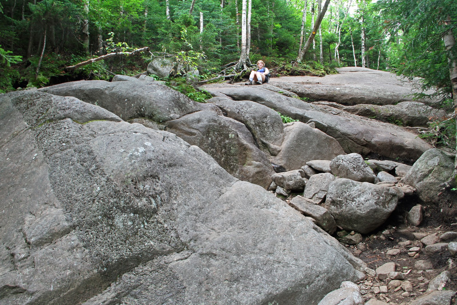
I have been jogging around this reservoir for thirty-five years. It was constructed in 1870
to supply the fresh water demands of growing Boston and its environs but is now a haven of tranquility in the heart of the city. I’m continually astounded by the diversity of the wildlife that one finds here: geese, ducks, swans, gulls, hawks, falcons, turkeys, heron, egrets, fox, coyote, raccoons, muskrats, mice, snakes, frogs, fish, and the usual collection of squirrels, rabbits, dogs and humanoids. And it's decorated with fantastic ledges of the Roxbury Conglomerate!
Chestnut Hill Reservoir, Chestnut Hill, Massachusetts


May
...and even turtles.
Chestnut Hill Reservoir, Chestnut Hill, Massachusetts


June
It's the world's tallest freestanding stone structure, standing sentinel over our nation's capital since 1884. The Washington Monument is incredibly photogenic. It virtually begs to be photographed.
The challenge is to capture it in a uniquely individual way. Architectural geology can be a lot of fun especially if you're familiar with the quarry of origination.  The obelisk's exterior is marble from Maryland, Texas and Massachusetts, while its interior backing is composed of sandstone and crystalline rocks (glassy intrusive igneous rocks) from Maryland. The Massachusett quarry is named the Lee Lime in my home state. Its carbonate rocks were part of a coastal shelf along the then, southern seaboard of the supercontinent of Rodinia over a billion years ago. They were subsequently metamorphosed into marble by the collisional events of the Taconic and Acadian orogenies during the Paleozoic. Knowing the geology seems to give greater depth (no pun intended) to any subject.
National Mall, Washington, District of Columbia


July
My colleague and I, while traveling through northwestern New Mexico, spotted the stone edifice from a distance. Not intending to stop, we became overwhelmed by its mystical presence and stayed for a day. Unlike our conventional
perception of volcanoes that exude lava and build up a conical, vertical structure, Ship Rock emplaced within the Earth's crust phreatomagmatically, gas-charging its magma when it hit the water table. Its maar-crater at the surface and over 3,000 feet of overburden have eroded away in the last 25 million years, give or take. That left the erosion-resistant diatreme as testimony to the fury, topping out at 1,583 feet. The wall-like linear structure off to the left is a radial dike, one of three major feeder-conduits that emanate from Ship Rock.
Ship Rock, San Juan County, New Mexico

 July
Between the San Juan Mountains on the west and the Sangre de Cristo Range on the east is an eight mile-long, 700 foot-high sand sea where you'd least expect it, in western Colorado. In fact, it's the tallest dune field in North America! Although its shifting sands rejuvenate with the whim of the wind, the erg remains in one place
in a perfect balance of sediment supply (from the only-true-desert-in-Colorado sands of the San Luis Valley), means of transport (wind and water) and accommodation space (embraced within the Sangre de Cristos). Although cast in the shadow of the late day sun, the dark color of the sand is due to quartz and the volcanic rocks of the San Juans. 
Wind-driven sand drifts up the windward slopes of the dunes and then cascades down the leeward slopes. The wind will sculpt the dunes until its windward side slopes gently and the leeward side is short and steep. Can you tell the direction of the prevailing wind?
  Great Sand Dunes National Park and Preserve, Colorado


July
I couldn't resist one more view.
Great Sand Dunes National Park and Preserve, Colorado
July
Volcanoes to the west in the Thirtynine Mile volcanic field and the Sawatch Range periodically filled the air 
with volcanic ash 35 million years ago. Carried by the wind, ash rained down on the region of ancient
Lake Florissant in Colorado, and along with mudflows, preserved a diverse Upper Eocene ecosystem of fish, insects, mammals and plant material. Silica derived from the ash, in a scenario remniscent of Pompeii, and its interaction
with planktonic blooms produced biofilms that retarded organic decomposition. Perhaps most remarkable
to be silicified are the VW-size tree stumps of Sequoia's, members of an ancient redwood forest
that blanketed the lake region. Notice the two, rusted ends of a saw embedded within the "Big Stump,"
a vestige of wanton and destructive fossil collecting in the late 1800's.
Florissant Fossil Beds National Monument, Florissant, Colorado
July
This amiable little fellow actually tried to sell me some auto insurance.
Florissant Fossil Beds National Monument, Florissant, Colorado
August
Minutes from Lake Placid in northern New York State, we're viewing the High Peaks Region
across a dry, pro-glacial lakebed drained by an active Holocene stream. Both formed 
after the retreat of the Laurentide Continental Ice Sheet at the end of the Pleistocene.
The bedrock throughout the region, unless buried below glacial erratics, till and outwash,
is Middle Proterozoic Grenville metanorthosite, final vestiges of the supercontinent of Rodinia.
North Elba, Adirondack State Park and Reserve, New York State

September
This over three-inch monster was spinning its web on my patio. Its the largest spider I've seen outside of the zoo. I've found the web-sheathed dens of tarantulas in the Grand Canyon but never any inhabitants. Taken at night, I illuminated the critter with a flash light to try and photograph its web.


August
For the second consecutive year, this brightly-colored, orange-yellow cluster of mushrooms arose from exactly the same location and at precisely the same time of year in my neighbor’s yard. They fruited on the stump of an aging Maple tree following a week of humid, soaking rains. Their scientific name is Omphalotus but are commonly known as the Jack O’Lantern mushroom. Under suitable conditions of day length, heat,
humidity and nutrition, spores in the soil germinate to produce hyphae. When hyphae of the opposite mating type meet (a romantic love affair made in the soil rather than in heaven), a fruitbody is produced, in this case a mushroom. Mushrooms possess the spore-shedding organs of a new generation. The mushroom and its spores is analogous to an apple and its seeds. The hidden mycelium beneath the soil is the "tree" (sort of). Mushrooms are fungi, nature’s morticians in the natural environment, beneficially biodegrading and nutrient-recycling. As we all know, not all of them are edible. These delectable-looking delicacies are deadly poisonous (as in difficulty breathing, drop in blood pressure, irregular heartbeat and respiratory failure). They also exhibit bioluminescence by glowing in the dark. I returned the following day to harvest a few and observe that peculiar property in a dark room, but my neighbor unfortunately excavated his crop before I could. Based on my calculations, next August there’ll be new specimens to collect. Lesson learned? Don't eat mushrooms that glow in the dark, and you never know what’s growing in your neighbor's yard.

November
Back in D.C. again, I couldn't resist one more shot of the Monument illuminated by the setting sun.
National Mall, Washington, District of Columbia


November
This was my very first try at High Dynamic Range (HDR) photography.
Taken at sunrise, the autumnal colors are totally natural.
This pond is in the heart of town next to a parking lot at the back of a shopping center.
Hammond Pond, Chestnut Hill, Massachusetts


 December
The last snow storm of 2012 was a mild nor'easter in Boston. It gets its name from the direction the wind is coming from. Regardless of the site of origin of the storm, the nor'easter has a low pressure area whose center of rotation is just off the east coast of New England and Atlantic Canada. Its counter-clockwise rotation produces leading winds in the left-forward quadrant onto land from the northeast. That usually translates into heavy snow or rain depending on the time of the year along with high winds, pounding surf and coastal flooding. By the way, "down east" refers to coastal New England and has its origins as a Maine term for sailing down wind to the east. Can you tell which direction is northeast from the accumulation of snow on the trees?
Chestnut Hill, Massachusetts


 That's it for 2012. Happy New Year!
From Doctor Jack (and Franklin the Border Collie)

Monday, December 24, 2012

The Adirondack Mountains of New York State: Part III - Climbing the Geology of the High Peaks

We’re facing north from the summit of Algonquin Peak, the second highest mountain in the State of New York (5,114 feet). In the foreground, Wright Peak (4,580 feet) displays two Holocene rock slides, typical of the Adirondack’s higher peaks. Just to the left of Wright, lowly Mount Jo stands reign over glacial Heart Lake, the base for our climbs. Lake Placid Basin is in the left, middle distance. In the August haze, Whiteface Mountain (4,865 feet) is perched on the horizon (left of center) with the Sentinel Range sprawling off to the right. Another 45 miles and you reach the end of the Adirondack’s elliptical, uplifted dome. There you’ll find the lowlands of the mighty St. Lawrence River flowing to the Atlantic Ocean from Lake Ontario of the Great Lakes. 


How did the Adirondack Mountains form? Please visit my post Part II here.

VESTIGES OF A SUPERCONTINENT
Virtually all of the bedrock in this Adirondack Mountain vista is Middle Proterozoic Grenville in origin. The last billion years were witness to the formation of the supercontinent-spanning Grenville mountain belt culminating with the assembly of Rodinia, to its fragmentation, to the Iapetus Ocean’s formation and eventual closure, to the supercontinent of Pangaea’s unification and rifting apart, and to the birth of the Atlantic Ocean. Blanketing Early Paleozoic marine assemblages have been unroofed by thermal doming of the Early Cretaceous. A hundred million years later, Pleistocene continental glaciation bulldozed the region at least four times, likely more, leaving its erosive signature everywhere. The story of the Adirondacks is indeed “Written in Stone.”


THE ADIRONDACK LOJ
In August, my daughter and I drove from Boston to the Adirondack Loj (correct spelling), a few miles south of Lake Placid, New York. The lodge is efficiently run by the Adirondack Mountain Club and served as our base for two days of geological exploration within the High Peaks region. The lodge is replete with home-cooked meals and bagged lunches for hikers. It is immaculately clean with private and family bunk-rooms, and a communal great room for relaxing beside a stone hearth. There’s even swimming and canoeing in crystal clear Heart Lake. Built in 1927, this idyllic “gem-in-the-woods” has it all: mountain hospitality, Wi-Fi access, education classes in geology, botany and mountain lore, and easy access to the high peaks. Go there (shameless plug)! 
For their website click here.


My daughter (and climbing partner) enjoys the night air outside the lodge.

And yes, that IS a moose head above the hearth!


GLACIAL HEART LAKE
The lodge is situated on the edge of most pristine Heart Lake in the shadow of Mount Jo at 2,340 feet. It’s diminutive by Adirondack standards, but after a short hike above the glacial talus that litters the region, anorthosite bedrock quickly crops out. Go a little further, and the gabbroic anorthosite becomes gneissic as its constituent labradorite feldspar crystals begin to align. Still further, the trail crosses a fine-grained, black camptonite dike. All that geology within a mile of the lodge!


Taken from the summit of Mount Jo above Heart Lake with Mount Colden (left), the MacIntyre Range including the Peaks of Wright and Algonquin (center), and precipitous Wallface (right of center) are separated by the NE-SW fault valleys of Avalanche and Indian Pass, respectively. From a wonderful National Geographic article entitled “Adirondack Park-Forever Wild” at www.ngm.national geographic.com and photographer Michael Melford at www.michaelmelford.com)

The geological verdict on the lake is still out. Some believe it's a kettle lake that formed when ice calved from the front
of a receding glacier. In this scenario the lake would have become established in the glacial outwash when the ice melted. An alternative origin depicts its formation in a glacially-scoured basin replenished by melting glaciers and eventually mountain streams. That would lend credence to the thought that Heart Lake and the adjacent drybeds with unmistakable beaches were once one large glacial lake. The outlet of Heart Lake flows north into the lake basin of South Meadow. We’re looking south at the foothills of the MacIntyre range just before sunset, tomorrow’s destination.


Tranquility will have a new meaning!


ADIRONDACK MOUNTAIN HIGH
After a restful night in the lodge (2,174 feet), we began our sunrise-ascent to Wright Peak (4,580 feet) which was a warm up for Algonquin Peak (5,114 feet) to follow. Both mountains are within the MacIntyre Range, named after the owner of the Tahawus open pit, iron mining operation in the 1800’s and titanium dioxide in the early 1900’s.


The MacIntyre Range stands apart from the surrounding peaks and extends for eight miles running NE and SW along the trend of the faults that confine it. Its steep SW slope forms Indian Pass, while the NE side defines spectacular Avalanche Pass. Our two-day plan was to climb the range from Wright to Algonquin on the first day and investigate the system of lakes within the fault-valley to the east of the range on the second day.


The Adirondacks have a distinctive look and feel right down to the moss-covered, gnarled tree-roots that seem to imprison boulders of glacial talus.


The rough and rocky trail starts out in unconsolidated glacial talus and till, and transitions to anorthosite bedrock. The verdant slopes and valleys of the Adirondacks contain a deciduous mix of aspen, ash, cherry, beech, maple and birch at lower levels and hardy evergreens at higher elevations that includes pine, spruce, hemlock and cedar.


A TRAIL OF ANORTHOSITE
It wasn’t until about 2,340 feet that we encountered our first outcrop of anorthosite bedrock as the going steepened. From then on, the trail was entirely on exposures of metanorthosite and anorthositic gneiss requiring lots of scrambling and more planning for each step. We’re looking uptrail at one such steep exposure. The pitch is very deceiving at about 40-45º. My daughter is actually sitting upright. What a place to traverse in a downpour! The bedrock has been stripped of 30 km (give or take) of Grenville overburden by erosion, exhumation and uplift.


Notice the intrusion of a wide dike through the anorthosite with a small apophysis (offshoot) from the main channel mid-way up to the right. I suspect this dike to be of pyroxenite in composition. It lacks the chilled margin of fine crystalline growth indicative of most regional dikes which would indicate rapid cooling; therefore, the magma contacted the anorthosite while it was still hot. However, notice the cracks perpendicular to the path of dike-emplacement. The dike had already cooled enough to contract.


There are many dikes in the Adirondacks of various tectonic causations and time frames. Examples include: Late Proterozoic dikes of alkaline basalts (meta-diabasic) that intruded Grenvillian crust during orogenesis; late- to post-orogenic dikes associated with extensional collapse of the Grenville orogen; dikes associated with the rifting of Rodinia and the opening of the Iapetus Ocean in the latest Proterozoic and Early Cambrian; Mesozoic tholeiitic dikes associated with the rifting of Pangaea and the opening of the Atlantic Ocean; and dikes associated with passage over the Great Meteor hotspot (more so eastern Adirondacks). Dikes are of significance in studying such processes as continental breakup, and the composition of the lithosphere and asthenosphere.


Many of the waterfalls in the Adirondacks are associated with dikes that succumb more readily to erosion than the surrounding resistant anorthositic country rock. Such is the case with this waterfall of MacIntyre Brook associated with several diabase dikes that crosscut the bedrock. At an elevation of 3,255 feet, it only had a trickle of water. One can imagine the raging fury during a summer thunderstorm.


Along the trail, we encountered frequent veins, likely quartz, cross-cutting the bedrock where tension-cracks in the rock admitted the injection of erosion-resistant, mineral-bearing solutions.


ANORTHOSITES OF THE HIGH PEAKS
“Proterozoic massif-type anorthosites” (Ashwal, 1993) were emplaced along the southeastern aspect of the Canadian Shield within the Grenville Province during the waning stages of the Grenville Orogeny. The Adirondack Mountains of northern New York State represent a southern extension of the Grenville Province (visit my post Part II for details here). Separated by the Carthage-Colton Shear Zone, they are topographically divided into Central Highlands and Western Lowlands. Our climb in the High Peaks region of the Highlands was entirely within the Marcy massif (orange) and surrounded by associated granitoids of the AMCG suite (stripes), a tongue-twisting, felsic and intermediate complex of anorthosite, mangerite, charnockite and granite.


Anorthosite and AMCG series distribution in the Central Highlands of the Adirondacks
(Modified from Chiarenzelli and Valentino, 2008)

THE “ANORTHOSITE PROBLEM”
Anorthosite is the most difficult igneous rock to explain. Its unique geochemical nature and puzzling tectonogenesis have intrigued geologists for almost a hundred years. Enigmatic are its: near mono-mineralic composition and large crystals of over 90% plagioclase feldspar (fractional crystallization in Bowen’s Reaction Series is generally 40-50%); its gabbroic parental magma (the precursor of any igneous rock); its enigmatic association with bimodal granitoid-suites (the AMCG suite); its low (less than 10%) mafic to intermediate (diorite and gabbro) rock composition; its restrictive occurrence as plutonic rocks; its presence with layered mafic intrusions; its emplacement largely confined to the Middle Proterozoic; and its unique tectonic setting (“anorogenic”).


Many of these petrological problems have been resolved, but their genesis has remained elusive. Clearly, they formed by igneous processes, but they can not have formed from a magma of their own bulk composition. The problem with anorthosite is its geochemical composition and begins with the generation of magma, the necessary precursor of any igneous rock. Magma that is generated by small amounts of partial melting of the mantle is generally of basaltic composition, which has the opposite composition found in anorthosite, lower plagioclase and no ultramafic rocks.


BOWEN’S REACTION SERIES
The series (delineated by a petrologist in the early 1900’s) indicates the temperature at which minerals melt or crystallize in magma. It also explains why some minerals are always found together and why others are almost never associated. Magma generated by partial melting of the mantle is generally of basaltic composition. On the series under normal conditions, the composition of basaltic magma requires it to crystallize between 50 to 70% plagioclase with the bulk of the remaining magma crystallizing as mafic minerals such as pyroxene. Thus, basaltic magmas are typically plagioclase- AND pyroxene-rich. Basaltic magmas of anorthosite, however, are defined by a much higher plagioclase content and much lower mafic content. In petrology, this is known as the “anorthosite problem.” 


Gabbroic anorthosites are plagioclase-rich and mafic-poor in content unlike conventional intermediate basaltic igneous rocks.
Note that granite, somewhat similar in appearance to anorthosite, is derived lower in Bowen’s Series and chemically unrelated.
(From ck12.org)

For a more detailed explanation of the Bowen Reaction Series click here.


AN ANORTHOSITE (THEORETICAL) SOLUTION
Although controversial for many decades, a consensus has developed to provide an anorthosite solution. Simply stated, anorthosites are considered to be the product of basaltic magma and that the removal of mafic minerals has occurred at a deeper level. A key point is the ascending asthenosphere that provides thermal energy to melt gabbroic magma that has underplated the lower crust. And also uniquely Adirondack is the intense deformation during or after crystallization that occurred which generated th
e re-crystallized parent liquids of anorthosite.

The following is a chronological model of how anorthosite, plagioclase-rich and mafic-poor, may have formed along with its associated AMCG suite. Note that the process is “anorogenic” in that ponded magmas evolved in an extensional and regional event not directly derived from normal mantle melting rather than in an “orogenic” convergent tectonic event. Although the suite represents a small percentage of the Adirondacks, the AMCG's are crucial in understanding the petrogenesis of massif anorthosite. For clarification of events related to extension within the Grenville Orogeny, please visit my post Part II here.


A THEORETICAL MODEL
(A) After accretion of the Grenville Province in the late- to post-tectonic setting of the Grenville Orogeny, delamination of over-thickened lithosphere (from the Grenville contractional orogeny) and post-collisional extension (during orogen-collapse) promoted an influx of gabbroic magma from the asthenosphere yielded by decompression melting. Having left its mantle source, the picritic magma (olivine-rich and plagioclase-poor) underplated the crust, ponded there and differentiated into a magma chamber.
(B) Crystallization of olivine and pyroxene (aka Bowen) occurred with these dense mafic (ferro-magnesium) phases sinking back into the mantle.
(C) The remaining crystal mush became enriched in plagioclase, Al and Fe/Mg. This lower-density, buoyant basaltic melt (now a plagioclase-rich anorthosite) began to diapirically (hotspot plume-like) ascend into the crust.
(D) Anorthosite further ascended as plutons.
(E) The plutons coalesced to form massive anorthosite. The rising, hot asthenosphere (a key point) provides heat to partially melt the lower crust resulting in the formation of granitoids which, along with anorthosite magmas, formed the AMCG suites coevally (at the same time) but not co-magmatically (from separate magma chambers).


Model of Anorthosite and AMCG Suite Petrogenesis
 (Modified from Ashwal, 1993)
 
Why is this massif-type of anorthosite largely Proterozoic? At the early stage of Earth’s history, the emplacement of anorthosites was likely fueled by the Proterozoic crust, still sufficiently hot from the post-Archean age, yet sufficiently cool and rigid to support the intrusion of mafic magma and yet hot enough to allow the downward draining of dense magma residua.
 

METANORTHOSITE
The end result is our anorthosite, a phaneritic (coarse-grained), plutonic (magma chamber), intrusive (formed under the surface), mantle-derived (but not from mantle-melting), igneous rock that is enriched with plagioclase feldspar (usually labradorite, andesine or sometimes bytownite related to Bowen's Series) and depleted mafic derivatives (such as ilmenite, olivine, magnetite or pyroxene). The formation of anorthosite and associated granitoids are thought to have occurred late in the Shawinigan Orogeny and metamorphically imprinted during the Ottawan Orogeny (see Part II).
 
Plagioclase imparts a gray to bluish-black color to anorthosite due to Fe-Ti oxide inclusions. Anorthosite boulders and cobbles typically bed the brooks in the High Peaks region. Notice its distinctive blue-gray, granite-like, speckled-appearance and its characteristic eroded cobble-form.


After anorthosite crystallized, tectonic collisions toward the end of the multi-phasic Grenville event metamorphosed the rocks. This close-up of Marcy-type anorthositic gabbro shows metamorphic reaction-rims with coronas of garnet (C) surrounding mafic pyroxene megacrysts (B) within the plagioclase feldspar's interlocking-matrix (A). After initial metamorphism, an influx of fluids, garnet and hornblende growth, and textural modifications occurred. Garnets are indicative of the high temperature and pressure of granulite-facies metamorphism that occurred during the Ottawan Orogenic phase of the Grenville Orogeny. Garnets, whose formation is not completely understood, are useful in interpreting the genesis of many igneous and metamorphic rocks and in particular the temperature-time histories of the rocks in which they grew and in defining metamorphic facies of rocks.

By the way, garnet has been designated as the official New York State gemstone. It's used in coated abrasives, glass and metal grinding and polishing, and even to remove the red hulls of peanuts. The Barton mine in the Adirondacks sells up to 12,000 tons annually harvested from an amphibolite. Chances are if you're using red sandpaper, it's from the Barton mine.


Referring to the Bowen Reaction Series above, the plagioclase family of feldspars displays numerous mineral phases as it cools and migrates from calcium- to sodium-rich. One of the minerals, labradorite, is a principal constituent in anorthosite and is responsible for its blue-gray color, actually attributable to black ilmenite within its crystalline framework. Another interesting feature is labradorite’s blue-green iridescence (also called Schiller effect, labradorescence, opalescence and chatoyancy) especially under water. In fact, Opalescent River, that flows into the lake of Flowed Lands (see post Part IV coming next) contains a preponderance of iridescent anorthosite. The bluish optical phenomenon is related to light diffraction and reflection within submicroscopic layering or exsolution lamellae of the labradorite.

And lastly, the ‘zebra-stripes’ or ‘record-groove’ effect that plagioclase, particularly labradorite, exhibits is related to twinning during crystal growth. Symmetrical ingrowth of crystals enables plagioclase’s identification in the field. 


Photomicrograph of plagioclase crystal under cross-polarized light
showing distinct banding effect called twinning
(From Wikipedia.com)
 

ASCENDING WRIGHT PEAK
The spectacular view from Wright’s treeless summit captivated my daughter’s attention with Pitchoff, Cascade and Porter Mountains off to the northeast. Cloaked in low, ominous, swirling, gray clouds, the temps plummeted 30 degrees with wind gusting 25-35 mph. Instantly cooling down, out came the fleece and windbreakers on this otherwise hot August day. The threatening skies had us wondering about the conditions on adjacent Algonquin and if there’d be a view at all. We would be duly surprised!


On Wright, two sets of prominent vertical joints in the anorthosite intersect at right angles. Jointing is actually widespread throughout the massif and is a manifestation of forces of compression that resulted in the NE-SW faults. In some cases jointing has slight offsets indicative of faulting. Faults are responsible for the formation of the NE-SW valleys, as well as the subordinate NW-SE valleys. We seldom see faults on the surface but are aware of their presence by the landforms they create: belts of high mountains separated by narrow, swamp or lake-filled valleys. Deformational folds exist in the anorthosite as well, but because of its nearly mono-mineralic composition, they are difficult to identify.


Notice the prominent vertical joints in the anorthosite that decorate the entire summit. Two sets of them intersect at right angles. Vertical jointing is common throughout the Adirondack massif and is a manifestation of the forces of compression that resulted in the NE-SW faults. In some cases the jointing has slight offsets indicative of faulting. Folds exist in the anorthosite as well, but because of its nearly mono-mineralic composition, they are difficult to identify.

On January 16, 1962, a jet-powered strategic bomber, 30 miles off course in bad weather, clipped the top of Wright during a training mission killing four men on board. Parts of the plane still litter the crash site. Coincidentally, earlier this summer I climbed Mount Humphreys, the tallest peak in Arizona. It too was struck by a bomber on September 15, 1944 killing 8 airmen. A bronze plaque on Wright memorializes the airmen who lost their lives in service to their country. 


THE ARCTIC-ALPINE ZONE
The Adirondack timberline is about 4,000 feet, where the sub-alpine forest transitions into treeless alpine tundra. Timberline is not simply a matter of elevation. After all, timberline in the Rockies is nearly 12,000 feet. Even elevation and latitude together do not tell the entire story. In fact, timberline can be substantially lower on a cooler north-facing slope versus a sun-exposed southern slope. Timberline is determined by a combination of conditions that include low temperatures, frequent frosts, high winds, thick snow pack, inadequate precipitation and poor soils, all of which diminish seed production and viability.  


The Arctic-Alpine Plant Zone is the rarest habitat in New York State on 11 of the highest peaks of only 85 acres in the entire state! Its plants are identical to those found in tundra arctic regions at high latitudes, being equivocal to extreme elevation. Alpine low mean annual temperatures, frost-free periods (only two months a year), exposure to wind and ultraviolet radiation, lack of sufficient and nutritious soils, and wind speeds are comparable to that of the arctic. The Alpine Zone in the High Peaks Region is restricted to the meadows of 14 summits and are relics of the Ice Age, common throughout the region as the last glaciers made their retreat about 12,000 years ago. The plant communities were forced upslope by warming trends and the expansion of the forests in order to sustain their optimal growing conditions. The vegetation faces extinction similar to the threats facing arctic plants as the climate slowly warms.


The tundra vegetation is very fragile and slow-growing confined to isolated patches on thin remnants of soil that tenuously cling to the anorthosite. This Deer’s Hair Sedge is a densely tufted grass-like perennial that grows in large, windswept patches. The vegetated region seen here is on the leeward side of the summit from the wind. Can you tell the direction of the prevailing winds from the twisted balsam fir? Small stones were brought to the summit (over four tons!) by hikers and placed as barriers to protect the plants from inadvertent human trampling. For the last twenty years, many of the higher peaks have Summit Stewards that camp down below and spend their days educating the public about everything Adirondack especially the rare and fragile alpine ecosystems.


ALGONQUIN PEAK
Compared to the windy, cold and overcast summit of Wright, Algonquin, 536 feet higher, was semi-tropical in the upper 70’s with bright sun and a gentle breeze. It’s a lesson in Adirondack weather on the summits. Even in summer conditions can change in a flash. Being prepared is essential to survival.


Our view to the east takes in massive Mount Colden (4,714 feet), scarred with landslides that look like huge vertical stripes. A veneer of thin soil, often less than a meter thick, tentatively mantles the slopes of many of the high peaks. Held in place by tangles of trees, shrubs, grassy roots and the coarse texture of anorthosite, soils on steep slopes can easily be destabilized by heavy, saturating rains.

Such was the case with Mount Colden during Hurricane Floyd in 1999 that delivered 10% of the annual regional precipitation in one day. In fact, Floyd’s was the single largest precipitation event recorded in the previous 71 years. The slide completely blocked Avalanche Pass with rock debris and a tangled mass of vegetation. More recently, Hurricane Irene in 2011 created the highly noticeable clean white slide. In all, I counted over 15 separate slides on Colden’s western face! Snow avalanches are a major threat to skiers and winter hikers as well in the pass. Mount Marcy is in the background to the left. At the base of Colden and out of view is a magnificent faulted-valley that contains a string of glacially-derived spillover lakes. We’ll visit those lakes tomorrow.


My daughter took this panoramic video with her iPhone. It begins and ends facing to the west.


Grass-like Deer’s Hair Sedge, the threatened rich-blue, close-mouthed Bottle Gentian and the deciduous, round-leafed alpine bilberry are prominent members of the alpine tundra community on Algonquin’s summit.


The elevation gain on our steadily-upward trek from the lodge to Algonquin’s summit including the side excursion to Wright was almost 3,000 feet! The elevation of the Adirondack “Forty-Six” High Peaks averages between 4,000 and 5,344 feet. Compared to other mountain ranges the summits might seem diminutive, but with an average ascent of 2,500 to 4,500 feet, the climbs are significant not to mention the geology. Leaving Algonquin, we returned along the same trail of our ascent to the lodge at Heart Lake. The total excursion for the day was almost 12 miles. Tomorrow, we investigate the geology of the lakes in the fault-bounded valley (post Part IV).


Saturday, December 8, 2012

The Adirondack Mountains of New York State: Part II – What do we know about their geological evolution?

 Yours truly atop Wright Peak in the High Peaks region of the Adirondacks


HUMAN HABITATION
The rugged and insular geomorphology of the Adirondack Mountains is attributed to their complex tectonic and glacial history. The mountains' geological past promoted a similarly colorful and varied history of human habitation. The word Adirondack is thought to be derived from a derisive Iroquois term toward the Algonquin tribe meaning “bark-eaters.” The phonetic spelling sounded similar to atiru’ taks. On old English maps the region was called “Deer Hunting Country” with “Adirondack” coming into usage around 1837.

Pleistocene deglaciation about 16,000 years ago opened the door to Native American hunting and fishing parties. During the eighteenth century, the Adirondack’s periphery saw the French and English struggle for control of North America. In the nineteenth century, the mountains enticed loggers and iron-miners, guides and hikers, dreamers and artists, and philosophers and poets. In the twentieth century, they witnessed titanium and magnetite-miners, climbers and naturalists, sportsmen and outdoorsmen, forest fires and logging-denudation followed by preservationists, environmentalists and tourists. 

Once blighted by logging and industry, the region has undergone a renaissance of woods and waters.” * Today, in the twenty-first century, the Adirondacks lives on as “a remarkable mix of wilderness and small towns in the midst of one of the most heavily developed regions in the world.” **

* Adirondack Park – Forever Wild by Verilyn Klinkenborg, National Geographic
** The Great Experiment in Conservation – Voices from the Adirondack Park by William F. Porter et al, 2009


BUILDING THE FOUNDATION OF A SUPERCONTINENT
“We now understand this ancient (Adirondack) terrain as a product of global tectonic processes that gave rise to the continents and ocean basins” of our planet. * In order to better understand how these processes formed the Adirondacks, we must look to some of the continent’s oldest rocks.

* The Great Experiment in Conservation:  Geology of the Adirondack Mountains by McLelland and Selleck

The ancient nucleus of the North American craton is the Canadian Shield (red) that formed during the Archaean and Early Proterozoic. It’s a two and a half to four billion year old, stable, igneous and metamorphic mosaic of accreted terranes and micro-plates that were progressively fused together by the process of plate tectonics. Shaped like a warrior’s shield, it was the first part of North America to remain permanently above sea level. One more massive terrane was needed to attach to the shield in order to finalize the supercontinent of Rodinia.

Today, the once-mountainous shield is a vast, gently-undulating, heavily-eroded and extensively-glaciated physiographic region of over three million square miles. From north to south, it extends from the islands of the Arctic Archipelago to the upper Midwestern states of Minnesota, Wisconsin and Michigan. From east to west, it extends from Greenland and Labrador of the Canadian Maritimes to the Canadian Northwest Territories. The Shield also exists in the subsurface beneath the Western Cordillera in the west and the Appalachians in the east.


Geologic bedrock map of North America with the Canadian Shield (red) embracing Hudson Bay.
The pointer is directed at Grenville bedrock (orange) and specifically the Adirondack outlier.
Notice the orange inliers in the Hudson Highlands, Reading Prong and within the Appalachians.
 (Modified from USGS)


ACCRETION OF THE GRENVILLE PROVINCE
During the Middle Proterozoic from ~1,300 to ~1,050 Ma, the Grenville Province (orange bedrock above) accreted to the Canadian Shield along its southeast boundary (contemporary coordinates). This was accomplished in a complex, long-lived, global-scale, tectonic collisional event called the Grenville Orogeny (after an exposure in a Canadian town in Quebec). The collision not only formed the Grenville orogen, an immense mountain belt, but it served to complete the final assembly of the supercontinent of Rodinia by bringing together most of the landmasses on the planet.

The ~3,000 kilometer-long and 600 kilometer-wide, supercontinent-spanning orogen was of Himalayan proportions that in North America extended from Labrador in eastern Canada to Mexico. Globally, the orogen reached as far as Australia, Antarctica and beyond in the west (contemporary coordinates), and in the east, Greenland, Scandinavia (Norway and Sweden), South America (Amazon) and Africa (Kalahari). This axis-sideways view of Middle Proterozoic Earth depicts the global extent of the orogen across Rodinia. The mountains in the region of the future Adirondacks (red ellipse) are Grenvillian NOT Adirondack, but the Grenville Province on which they would rise (orange blob at the arrow above) was in place!
 
(Modified from Scotese.com)

This cartoonish representation (~700 Ma) shows the extent of the Grenville orogen (reddish-brown) running through Rodinia’s building blocks. After Rodinia’s final assembly, it would fragment (rift) apart. Smaller cratonic blocks would be sent tectonically adrift along with the Grenville rocks they acquired. After the craton of Amazonia fragmented from Rodinia, the region of the future Adirondack’s (white dot) would assume a coastal locale. Geologists are studying the Grenvillian rocks on ancient continents far-adrift in an attempt to piece together the collisional events that formed Rodinia, and the details and timing of its fragmentation.


(Modified after Callan Bentley, 1991)


VESTIGES OF RODINIA
The fate of all orogens is their eventual reduction to a low-lying peneplain. Thus, the mountain belt’s long and complex history of igneous intrusion, metamorphism and deformation is represented today by ongoing degradation (erosion) and exhumation (exposure). In North America, the Grenville Province’s presence in the subsurface of the Appalachians (diagonal lines) is extensive, having been overprinted subsequently by the Appalachian Orogeny (although recently the southern and central Appalachian basement crust appears to be exotic). Surficially, it extends into southeastern Canada (yellow) and outliers of the Adirondack Mountains (green AD). It surfaces again in the Hudson Highlands, the Manhattan Prong of New York and inliers of the Appalachians (black blobs), and down south in Texas and Mexico. Globally, vestiges of Rodinia are present in the cratons of rifted landmasses that once formed the supercontinent.

Allochthonous (yellow and green) Grenville rocks thrust upon autochthonous (indigenous) rocks,
making much of the Grenville Province “reworked” older continental crust.
The Grenville Front separates the Grenville Province from the Canadian Shield.  
 (Modified after Rivers et al, 1989)
 

DEMYSTIFYING THE GRENVILLE OROGENY
Lay descriptions of the orogeny depict it as a singular, protracted mountain-building event. In reality, it consisted of a multitude of events spanning perhaps 300 million years and is best viewed as a collection of collisional and magmatic phases separated from each other by 50 to 80 million years. The scenario is somewhat analogous to the more recent long-lived Appalachian Orogeny that includes Taconic, Acadian and Alleghenian phases or episodes.

Although dates and details vary considerably and are controversial, the phases of the collective Grenville event are: the Elzevirian orogeny (1350 to 1220 Ma), the Shawinigan orogeny (1180 to 1170 Ma), magmatism of the enigmatic AMCG (anorthosite-mangerite-charnockite-granite) suite (1160 to 1150 Ma), the Ottawan orogeny (1090 to 1050 Ma) and the Rigolet orogeny (1010 to 980 Ma). The Grenville timeline might look something like this.

A-F coincides with panels below
(Timeline by Doctor Jack)


DEMYSTIFYING THE PHASES OF THE GRENVILLE
To gain a sense of how the Adirondack’s bedrock was derived, here’s a VERY abbreviated synopsis of the Grenville’s phases assimilated from numerous sources most notably from McLelland et al.* Importantly, the proposed terrane of Adirondis (red letters) is thought to have formed the basement of portions of Quebec to New Jersey (MC, VT, NY, NJ) and includes the Adirondack region!

The Canadian Shield (light gray) experienced rifting (gray arrows), opening and closing (black arrows) of the Central Metasedimentary Belt (CMB) of the Grenville Province in the Middle Proterozoic. This allochthonous belt was thrust to its location in the ensuing arc-collision. Adirondis is thought to have rifted from the North American craton and then reattached (A-D). The Elzevirian (B) and Shawinigan (D) orogenies and the enigmatic, mantle-derived AMCG suite magmatism (E) provided additional metamorphism, deformation, and further contributed to the formation of the Adirondacks. Note that the AMCG suites formed anorogenically due to lithospheric delamination and tectonic transportation in large thrust slices and nappes, and were emplaced in two intervals (1160-1130  and 1080-1040 Ma). 

The Phases of the Grenville Orogeny
 (A) Adirondis rifting; (B) Elzevirian east-directed subduction zone;
(C) Back-arc basin closure and Adirondis accretion; (D) Shawinigan CMB thrusting;
(E) AMCG suite intrusions; (F) Ottawan thrusting of Grenville rocks over the shield’s foreland.
MA, Marcy Anorthosite of the High Peaks region.  
(Modified from McLelland et al, 2010)

The Grenville Orogeny ended with deformation and metamorphism during the Ottawan phase (F) which is considered the main orogen-wide, continent-continent collision and the culminating event in the evolution of the Grenville Province. Convergence is thought to have occurred when one or more continental blocks (likely including the South American craton of Amazonia although collisions with Baltica and the Kalahari have been implicated) collided with Adirondis and the previously accreted Grenville terranes. The orogeny is comparable to the convergence of India with Asia that created the Himalayan Mountains and the Tibetan Plateau in terms of magnitude, crustal thickness, metamorphic fabric and tectonic design.

* Review of the Proterozoic Evolution of the Grenville Province, its Adirondack Outlier, and the Mesoproterozoic Inliers of the Appalachians  by McLelland, Selleck and Bickford, GSA, Memoir 206, 2010.


THREE GEOLOGIC SUBDIVISIONS OF THE ADIRONDACKS
The final outcome of the multi-phasic orogeny was the Grenville Province that includes a southern extension or outlier in northern New York, the locale of the future Adirondack Mountains. The tectonic and magmatic history of the Adirondacks is extremely complex. The timing of deformation, the identification of sutures, and the clarification of phases responsible for structural features remain unclear due to overprinting, metamorphic obscuring of boundaries and bedrock inaccessibility.

Today, the Adirondacks are divided into three terranes based on metamorphic grade, rock type and structure. Their rocks are metamorphic almost without exception, having been subjected to high temperatures and pressures at depths of 19-25 miles (30-40 km).

The three recognized subdivisions are:
 
1.) The Central Highlands (red HL) is a mountainous terrain underlain by erosion-resistant igneous rocks that were metamorphosed under granulite facies conditions (high temperature and pressure during the Shawinigan and Ottawan orogenies). Its meta-plutonic rocks include orthogneisses, meta-anorthosite, a voluminous AMCG suite and olivine meta-gabbro. The High Peaks region is located within the center of the Highlands with the Marcy Massif as its centerpiece. The red ellipse denotes the region of our geologic ascent in post Part III.

The three subdivisions of the Adirondacks in northern New York State
(Modified from Huemann et al, 2006)

2.) The Northwest Lowlands (red LL), a smaller, topographically-subdued region. Its varied rocks include metamorphosed sedimentary rocks of shallow-marine origin (notably marble, quartzite and gneiss) that are folded, faulted, and then intruded by metamorphosed volcanic rocks. These supracrustal rocks were metamorphosed to amphibolite facies (intermediate temperatures and pressures) during the Shawinigan orogeny. The Lowlands are contiguous with the main Grenville Province in Canada via the Frontenac Arch which extends across the St. Lawrence River in the region of the Thousand Islands. It is a terrane that is lithologically similar to the Lowlands, and many consider the Lowlands to be part of it.

3.) The Carthage-Colton Mylonite Shear Zone (red CCZ) is a kilometers-wide, major northeast-trending, ~45º northwest-dipping fault and terrane boundary that separates the two above domains. Its shear zone is a major Ottawan Orogeny extensional feature. The Lowlands were thrust over the Highlands along a  suture zone coincident with the present Carthage-Colton Zone.


WHAT GOES UP MUST COME DOWN
With the orogen and mountain-building complete, and the removal of convergent tectonic driving-forces, compression changed to extension. The constructive phase of mountain building was succeeded by a late-stage, destructive phase as erosion and sediment transport overwhelmed the orogen. The orogen’s over-thickened crust gave way under its own weight spreading laterally. Syn- (at the time of) through post-orogenic collapse is a fundamental process in the tectonic evolution of mountain belts.

Tectonically in brief, the over-thickened lithosphere of the orogen is removed either by delamination or convection which allows asthenosphere to well upward. The buoyant asthenosphere undergoes compression melting forming ponded gabbroic magmas that further fractionate, and exerting upward (POP UP) and outward (Fb), extensional vectors. In this manner, it is thought that the plagioclase-rich anorthosite (black squares) and the enigmatic AMCG suite (MCG) typical of the anorthositic massifs of the High Peaks may have developed. Obviously over-simplified, but we can see how orogenic collapse contributes to the formation of the Adirondack’s magmas. The genesis of the magmas is referred to as “anorogenic” emplacement (versus orogenic emplacement). 

Overthickened collisional orogen undergoing lithospheric delamination, consequent orogen rebound
and collapse along low-angle, normal faults during late phases of orogenesis.
(From McLelland, 2010)

In addition, many of the NE-striking faults found throughout the region may have originated as normal faults during this period of Late Proterozoic extension. These faults and additional from the Paleozoic were re-activated at various times and are responsible for much of the Adirondack’s contemporary landscape!


Cartoon of orogen collapse after asthenospheric upwelling has produced orogen rise,
lateral spreading and extensional faulting.
(Modified from Selverstone, 2005)


By ~1,020 Ma, the orogen's broad, elevated topography began to gravitationally collapse (the destructive phase). The Rigolet Orogeny (1,010 to 980 Ma) was an independent, final phase involving renewed orogen-wide contraction and additional collapse. Over 30 km of rock was stripped away as the majestic Grenville range was reduced to a peneplain of low relief, exposing the deep core of the mountain belt at the surface. The Adirondack Mountains still had not yet formed, but their basement rocks, the very core of the Grenville orogen, were now in place!


BREAKING UP IS HARD TO DO
Rifting typically follows the final consolidation of a supercontinent and ultimately results in its demise. Its continental crust is both thick and brittle, and becomes a trap for the buildup of heat. Tectonic movements generate stresses greater than the crust can sustain causing the supercontinent to rift apart, often along inherently-weak convergent boundaries. Following Rodinia’s breakup, fragmented cratonic blocks as newly-formed continents were sent tectonically adrift throughout the globe taking along their share of the Grenville.

Traditional Rodinia models argue that breakup on Rodinia’s west coast commenced with the opening of the Panthalassic Ocean (Paleo-Pacific) at 800 to 700 Ma between the conjugates of Australia and East Antarctica, while on the east coast, the Iapetus Ocean (Paleo-Atlantic) opened by 600 to 535 Ma. With the cessation of ongoing tectonic activity both coasts were converted from an active rift-margin into a passive rifted-margin.

(Modified from Dalziel, 1997 and Torsvik et al, 1996)

This Mollweide Projection (note the equator for orientation) shows the postulated position of Rodinia (~750 Ma) shortly after breakup with South American terrane of Amazonia beginning to disengage. The newly-formed continents of Laurentia (~550 Ma) and Western Gondwana are separated by the nascent southern Iapetus Ocean. Black shaded areas are Grenville mobile belts. Red arrow points to the region of the future Adirondack Mountains.

 (Modified from Cocks and Torsvik, 2005)


RIFTING TO DRIFTING > ACTIVE TO PASSIVE > SUBSIDENCE AND SEDIMENTATION
As the developing rift widened into the expanding Iapetus Ocean on the east (south using Cambrian coordinates), Laurentia’s passive margin was characterized by subsidence and sedimentation. Low-lying coastal regions including the region of the future Adirondacks were flooded by rising global seas (possibly caused by the many shallow ocean-basins following Rodinia’s fragmentation, rapid seafloor rift-spreading and/or thermal subsidence of passive margins). As mentioned, many of the NE-striking faults found in the region of the Adirondacks and throughout the state may have originated as normal faults during this rifting-period of Late Proterozoic extension.


Middle Cambrian (500 Ma) Laurentia with flooded coastal and cratonic regions
inlcuding the region of the future Adirondack Mountains.
(From Ron Blakey, Colorado Plateau Geosystems, Inc. and courtesy of Wayne Ranney)

As the rising Cambrian Sauk seas flooded the landscape, a thick wedge-shaped blanket of siliciclastic sand and mud covered the surface of the Grenville basement followed by an overlying carbonate system in deeper waters. The sandstone-shale-limestone assemblage transgressed with the rising seas advancing landward and drowning most of Laurentia’s craton. For the record (and everyone that thrives on names and details), the entire sedimentary package is referred to as a Sauk (the first global high-water of the Phanerozoic of which there are six) Supersequence (a conformable, time-orderly succession of strata) of Sloss (the proposing sedimentary geologist).


ADIRONDACK REGION IN THE EARLY PALEOZOIC
Thus, in the region of the future Adirondacks, the eroded Middle Proterozoic Grenville basement rocks were overlain by Late Cambrian to Early Ordovician Potsdam Sandstone (yellow) followed by an overlying limestone-dolostone sequence of the Theresa Formation and the Beekmantown Group (light gray). The contact between the two rock layers represents a billion-year-plus gap in time called an unconformity. It formed due to a prolonged interruption in deposition and/or protracted erosion, likely both. The amount of missing time (and strata) is so massive that it has achieved capital letter status in the geological literature called the Great Unconformity. And, it’s global in its extent, found wherever a Paleozoic sequence overlies a Precambrian basement.

(Modified from the Geology of New York, 2000)


The Potsdam Sandstone is the geological and temporal equivalent of the Tapeats Sandstone, the basalmost strata of the classic-textbook, time-transgressive Tonto Group within the Grand Canyon. The Great Unconformity between Middle Proterozoic Vishnu Schist and the overlying Middle Cambrian Tapeats formed on Laurentia’s west coast. It is the same time-gap that we see on the periphery of the Adirondacks!


ADIRONDACK REGION IN THE MIDDLE TO LATE PALEOZOIC AND MESOZOIC
From the Devonian through the Mesozoic, the Adirondack region remains poorly constrained. With the arrival of the Taconic Orogeny in the Middle Ordovician, loading and subsidence due to Taconic Allochthon overthrusting resulted in the creation of additional normal faults within the Grenville basement and the reactivation of pre-existing Grenville ones, as well as burial of much of the eastern Adirondacks. Like the Taconic, the subsequent Acadian Orogeny during the Middle to Late Devonian further subsided and buried portions of the Adirondack region.

The final event of the Appalachian orogenic cycle in late Pennsylvanian to Permian time brought the Alleghenian phase to the northeast, this time with the eastern Adirondacks experiencing slow uplift and exhumation. Mesozoic continental rifting of Pangaea likely prolonged regional exhumation. Still, no mountains existed in the region of the Adirondacks, but the geological stage was set with a Grenville basement covered by a Sauk sequence, exposed and fault-scarred!

The following map displays known faults and lineaments within the State of New York. The strike pattern is the cumulative result of Grenville and Appalachian orogenesis, Rodinian and Pangaean rifting. The scars within the basement structure will serve to dictate the presentation of landforms in the Holocene.

(Modified from Fakundiny et al, 2002)


ADIRONDACK REGION IN THE EARLY CRETACEOUS
As the North American plate tectonically drifted northwest, it passed over the stationary Great Meteor hotspot (also called the New England hotspot). A hotspot is a hypothetical region of mantle-derived, voluminous volcanism in the form of a thermal plume that upwells to the surface. The plate’s passage produced a somewhat linear track or age progression of igneous intrusions of various compositions on the surface.

The hotspot track can be traced by a line of kimberlite dikes in the Laurentian Uplands of Quebec to Mont Royal in Montreal, the Monteregian Hills magmatic complex east of Montreal, into northern New York and New England with intrusions of hypabyssal dikes, and off the coast of Massachusetts with the New England Seamounts (e.g. Corner, Nashville, Gosnold and Bear). The seamounts are a line of extinct, submarine volcanoes that extend over 1,000 km along the track. At about 80 million years, the Mid-Atlantic oceanic spreading center migrated to the west over the hotspot. The track of the hotspot continues on the African Plate at the Great Meteor Seamounts off the coast of West Africa from which the hotspot gets its name.


Generalized map of the Great Meteor hotspot track
(Modified from Duncan, 1984)


This topographic map demonstrates the Great Meteor’s surficial features. Trace the track from the Monteregian Hills (M) through New England (NEM) including the Adirondacks (red arrow) and past the Great Stone Dome (GSD), an intrusion into passive margin sediments domed by pressure-release melting. The track follows the submarine New England Seamounts across the Dynamic Gap and to the Cormer Seamounts (offset due to seafloor spreading). It then crosses the mid-Atlantic ridge to the African plate and continues as the Great Meteor Seamounts off the African coast.


(Modified from Smith and Sandwell, 1997)


THE ADIRONDACKS GET THE LIFT THEY NEEDED
The hotspot is thought to have induced regional heating between ~125 and 100 Ma in the vicinity of the Adirondack Highlands, as the North American plate on which it rides migrated over it. The scenario is analogous to the Hawaiian Island chain and Yellowstone magmatism. Mantle lithosphere under the hotspot is suspected to have delaminated thereby producing dynamic uplift as the buoyant asthenosphere welled up to replace the mantle lithosphere.

The result is ~1 km of domal uplift of the Grenville basement of rocks giving rise to the Adirondack Mountains forming “new mountains from old rocks.” In addition to re-activated normal faults in the Adirondacks during the orogenies of the Paleozoic, it is plausible that thermal doming may have contributed to additional re-activation in the region.

(Modified from Geology of New York)


THE GREAT UNCONFORMITY OF THE ADIRONDACKS
The thermal doming of the Adirondacks unroofed the Early Paleozoic Sauk sequence that once covered the region and re-exposed the Middle Proterozoic Grenville basement. On the periphery of the dome where uplift is minimal, the sedimentary cover and the intervening time gap of the Great Unconformity can be found.

(Modified from Geology of New York)


ADIRONDACK GRAVES
How do we know that the region of the Adirondacks was once covered by sandstones and limestones, if the sediments were unroofed and now missing from the dome? Because the transgressive sequence surrounds the periphery of the range and from down-dropped grabens that contain Cambrian and Ordovician rocks in the southern Adirondacks. These geological “graves” that formed in the extensional Grenville regime protected the landscape from erosion while uplifted horst-blocks were eroded during regional uplift. We are reminded of the preservation of the Grand Canyon Supergroup within erosion-protected, down-dropped grabens.


(Modified from Artemis at MIT)

ENIGMATIC UPLIFT *
Q.  Why did doming occur in the Adirondack region and not elsewhere along the hotspot track? Why is there not a train of Adirondack-like mountains along the track?
A.  The lack of an uplifted-track may be due to a failure of the plume to penetrate the Canadian Shield or a strengthening of the plume as it tracked eastward. The answer likely lies in the structure of the lithosphere and mantle under the Adirondacks relating to dynamic support.


An alternative interpretation of the hotspot model relates to the inferred hotspot as it encountered a progressively thinning lithosphere due to the motion of the overriding plate. Notice the path of the earthquake epicenters (black line) along the hotspot track in Quebec and New England. Earthquakes can be used as an indirect measure of magmatism and to measure its track out to sea. The track crosses two large orogenic belts that cut across the region, that of the Grenville and Appalachian orogenies. The heavy lines are failed rift arms (characterized by normal faults and mafic dikes) emplaced subsequent to the rifting of Rodinia and the opening of the Iapetus Ocean. A comparison of the track with pre-existing crustal structures suggests that a reactivation of structural features may have occurred. The emplacement of buoyant asthenosphere may account for the systemic evolution on the surface of kimberlite dikes to more voluminous crustal magmatism and Adirondack doming.


Earthquake epicenters align with the Great Meteor hotspot track (dashed line),
while Grenville and Appalachian orogenic belts transect the region.
Adirondack region at red arrow.
(Modified from Shutian and Eaton, 2007)

Q.  Why are there seamounts in the Atlantic basin along the track?
A.  Seamounts occur along hotspot tracks in oceanic lithosphere which is thinner than continental crust. Hotspots readily melt material at the base of the crust generating submarine magmatism.


Q.  If cooling is occurring in the Adirondack region with the passage of the hotspot, could uplift still be taking place other than from glacial isostatic rebound?
A.  If uplift is indeed present, it would be related to dynamic support within the lower crust and mantle.


Q.  Why are there no extrusive volcanics in the Adirondacks as in hotspot-related Yellowstone and the Hawaiian Islands?
A.  The possibility exists that magmatism may have occurred in places within the mountains and has since eroded away. Perhaps the intrusive stocks in Canada are erosive remnants that fed long-extinct volcanoes. Projecting the track to the west in Canada where it appears devoid of surficial volcanic activity, intrusives may not have reached the surface. Unconfirmed seismic reflectors in the middle and lower crust under the eastern Adirondacks do imply the presence of a mafic intrusion of the same age at depth. Again, we must look to the mantle for an answer.


* Personal communication, name withheld


ICING ON THE CAKE
With incipient accumulations in the Middle Pliocene and in earnest by the Pleistocene, the two-mile thick North American Laurentide continental ice sheet covered hundreds of thousands of square miles throughout the majority of Canada and northern United States a multitude of times. Better known as the Ice Ages, the furthest southern extent of the continental glaciations surpassed New York City and Chicago with a mid-continent terminus of approximately 38º latitude. The ice sheet created much of the surface geology of southern Canada and northern United States by gradually bulldozing its way through the landscape.


The northeast extent of the Laurentide Ice Sheet during the Late Wisconsinan Stage.
Blue, 14,000-18,000 ky; Turquoise, 10,000-14,000 ky; Dark blue, 6,000-10,000 ky.
Red line is the end moraine. Red arrow points to the Adirondack region.
(Modified from Geographie Physique et Quaternaire from erudite.com)

After some two million years of glaciation, about 10,000 years ago the ice had fully retreated from the Northeast including the Adirondacks. With the coming of interglacial warming trends alpine glaciers continued the work of scouring the upper reaches of the Adirondack’s now-elevated landscape and are responsible for the distinctive, sculpted and scoured appearance of the region today. The eroded, domal architecture of the Adirondacks has dictated the configuration of its landforms and the path of drainage that its waterforms have chosen to take. Once radial in design, the Adirondack’s lakes, rivers and streams have begun to adapt a trellis pattern as they eroded into resistant Grenville bedrock and followed the NE-trending faults in the landscape. This NASA satellite photo of the Adirondack Mountains shows the ranges, valleys and waterways that orient with the strike of the prevailing bedrock structures within the Adirondack Mountains. 


(From earthobservatory.nasa.gov)

Some workers have proposed that the Adirondacks are still experiencing uplift at a rate of ~1 to 3 mm/yr due to prolonged thermal doming; however, this hypothesis remains controversial. Other hypotheses explain contemporary uplift, if truly active, by an isostatic response to crustal thickening relating to Great Meteor Mesozoic magmatism or post-glacial isostatic rebound.


THE ADIRONDACKS OF TODAY
We’ve witnessed the emplacement of the Adirondack’s crystalline basement via Middle Proterozoic Grenville orogenesis well over a billion years ago. After Late Proterozoic mountain belt collapse and erosion, exhumation brought the deep roots of the orogen to the Earth’s surface. Latest Proterozoic rifting fragmented Rodinia, and Early Paleozoic high seas flooded the region with the Sauk sequence of deposits. Multi-phasic Appalachian orogenesis further exhumed and scored the region with faults and fracture zones. Late Cretaceous passage near the Great Meteor hotspot uplifted the Grenville foundation into the Adirondack range followed by Pleistocene glaciation that sculpted the region. Voila!

The Adirondack’s complex geological history explains their enigmatic intraplate locale at a considerable distance from the Appalachian passive margin of the continent. We now understand how the Adirondack Mountains appear to be part of the Appalachian chain but are uniquely independent geographically, tectonically and temporally. And finally, having derived their structure from ancient Precambrian rocks, we see they are truly “new mountains from old rocks.”

Please visit my upcoming post on the Adirondacks entitled Part III "Climbing the Geology."