Monday, October 24, 2011

Part II: Geological Observations by Land and Sea of the Champlain Thrust Fault at Lone Rock Point


This fall I visited Lone Rock Point, a rocky promontory just north of Burlington, Vermont, on the eastern shore of Lake Champlain. The locale displays a spectacular outcrop of the Champlain thrust fault. At the contact, the buff-colored Lower Cambrian Dunham Dolostone overlies the dark gray to black-bedded Middle Ordovician Iberville Formation.


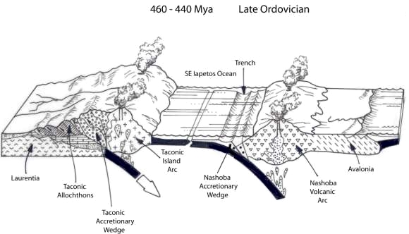
In my previous post entitled "Part I: The Tectonic Genesis of the Champlain Thrust Fault at Lone Rock Point" I reviewed the tectonic events, both global and regional, leading to the creation of the thrust fault at the point. Also, I described how the reversed stratigraphic architecture of the thrust's component formations occurred.

It's time to visit the point, first by sea.  


Photo Below:
Seen from the water on the northern edge of Burlington Bay, we are looking down the south-face of Lone Rock Point towards the mainland (the sandy beach at the far end). On this side of the promontory, the cliff-face is formed mainly of Iberville Shale with a variable cap of Dunham Dolostone.


Photo Below:
Having just rounded the point, a segment of the Champlain thrust slice comes into view on the north side of the promontory. A massive block of dolostone has cascaded from the cliff-face, and a few others can be seen along the shore. Numerous light-colored, mass-wasting scars can be seen on the cliff-face. The shoreline is composed mostly of flat, highly polished, eroded pieces of shale (where the shore hasn't been drowned by the lake's recent high water), but relatively few massive, boulders of dolostone are found. This leads me to believe that the dolostone's erosion from the cliff-face and subsequent removal probably occurred much closer to the period of regional glaciation (ending about 10,000 years ago give or take) rather than recently. The scarp stands about 50 to 85 feet above the lake, which was running high, as mentioned, due to atypically heavy rains and Hurricane Irene. It is clearly evident that the erodable and fissile shale below the contact is basically undermining the overlying dolostone.


Photo Below:
We’re now looking back at the point. Burlington Bay lies on the far side of the promontory. Lake Champlain continues to the south for another 35 miles. The Green Mountains of central Vermont are on the horizon with the peaks of Camel’s Hump and Sugarbush barely visible. That’s dolostone holding up the point with shale at the base. A large section of "fresh" cliff-face can be seen with dolostone-talus at the shoreline. A "lone rock" island of dolostone hovers nearby, perhaps the namesake of the point.

 
Photo Below:
This is a straight-on view of the thrust slice at the north-face, the view seen in many geology textbooks. Viewing the thrust locality from the lake afforded me an excellent opportunity to gain a sense of the massivity and size of the slices. The thrust contact is sharp and surprisingly straight. In the early 1800’s, the thrust fault such as at Lone Rock Point was considered to be an unconformity between the underlying Ordovician shales of the “Hudson River Group” and the overlying dolostones of the “Red Sandrock Formation.” The Sandrock was thought to be of Silurian-age, since it bore a lithological similarity to the Medina Sandstone of nearby New York State. By mid-century, the noted geologist Edward Hitchcock and others correctly interpreted the contact as a major fault of regional extent based upon pre-Medina-age fossils in the Sandrock Formation. It is now recognized that the Champlain thrust fault is one of several important faults that floor major slices of Middle Proterozoic crust exposed in western New England.


Photo Below:
In addition to viewing the locality from the lake, I struck out on foot to view the fault and its component formations up close. The less resistant Iberville shale, further weakened by shearing at the fault, can be seen to have eroded from below the contact and undermining it in the process. The shale has developed a multitude of vertical joints and is gradually exfoliating from the cliff-face in an inverted-step pattern. The region of the contact is riddled with small grooves and larger corrugations within the resistant overlying dolostone, as it slid over the shale. The dolostone’s undersurface along the thrust reveals numerous fault mullions which plunge 15° to the southeast. The average southeastward dip of the thrust is 10°. Bedding in the shale can be seen to have been subjected to slight folding and deformation.


Photo Below:
This close-up of the contact shows the resistant planar fault surface on the under-aspect of the dolostone, the roof of the contact. The underlying black shale below the contact exhibits marked fissility, and slight deformation and folding. The intermediary region within the contact displays a very obvious brecciated zone of angular clasts distributed in a finer matrix. 


Photo Below:
This perspective is actually afforded from within the contact looking upward at the inferior surface of the dolostone at a distance of two feet. Indicative of movement along the fault surface, numerous straight lineations, striations and grooves called slickenlines are discernible running from upper left to lower right on the polished, inscribed slickensided-surface. Slickenlines are created as the fault surfaces abrade against each other. Mineral growth becomes aligned with the direction of slip along the fault recording the last direction of movement across the fault surface.


Photo Below:
In other areas along the contact, large slivers of dolostone and limestone embedded in a highly contorted matrix of shale can be found along the trace of the thrust in the brecciated zone. Some sources indicate that the slivers of limestone may represent pieces of the Beekmantown Group, a Lower Ordovician shallow marine, largely carbonate strata on Laurentia's passive continental shelf. 


Photo Below:
With the exception of jointing and karstic-induced irregularities on the uppermost surfaces of the Dunham dolostone, mostly minor structures were found in the body of the formation. On the other hand, the underlying Iberville Formation is riddled with deformed beds of gray and black shale, and white interbedded veins of carbonate that are finely bedded. Compression has caused the rock layers to bend plastically resulting in their deformation. The folds are essentially concordant with the plane of the contact. Deformation in the shale is most likely related to Taconic compression. Indeed, deformation seems to be more pronounced with increased proximity to the contact. Possibly some deformational overprinting exists, since the fault system is thought to have been reactivated during the ensuing Acadian Orogeny in the middle Paleozoic. Even some tectonic affect during the late Paleozoic Alleghenian Orogeny can not be ruled out, but seems less likely owing to its more southerly location. Asymmetrical drag folds with gently curved hinges were fairly abundant. I suspect that the presence of deformed, thin layers and lenses of white carbonate are related to the influx of water that was infused post-depositionally, since carbonates appear between shale beds but also cross-cut to the bedding. Close examination also reveals S and Z-folds and pull-apart structures in the shale beds, and small-scale boudin-like bodies in the carbonates. The fractal nature of the deformed bedding, evident even in the smallest of observations, has far greater tectonic implications.


Photo Below:
Occasional remnants of Early Cambrian bivalves can be found imbedded in the matrix of the dolostone. I found a few distributed in a narrow horizon. I suspected their presence in the formation but had to search hard to find them. Lichens cover many of the exposed dolostone's surfaces which is often pockmarked by karstic dissolution.


Photo Below:
This photo was taken at the end of the promontory high above the lake on a surface of heavily karstic-etched dolostone. At the day's end, the sun was getting low in the sky over the Adirondacks across the lake to the west. It was a glorious day in northern Vermont for October with blazing sun, rich autumnal colors, and perfect 85 degree weather, likely the last hurrah before cold winds foretell what's to come. 


Photo Below:
Back at the waterfront in the town of Burlington, the festive 4th Annual Giant Pumpkin Regatta was in full swing replete with watercraft of hollowed-out, 1000+ pound pumpkins!


Sunday, October 23, 2011

Part I: The Tectonic Genesis of the Champlain Thrust Fault at Lone Rock Point


This October I visited the most well known natural feature in Vermont, certainly amongst geologists. Lone Rock Point displays a spectacular outcrop of the Champlain thrust fault. This fault is often pictured in geological texts as possessing many of the features characteristic of fault thrusts throughout the world.


The buff-colored Lower Cambrian Dunham Dolostone overlies the dark gray to black-bedded Middle Ordovician Iberville Formation, a member of the Trenton Group on proto-North America's marine shelf. The fault is clearly visible as a sharp contact between the two rock formations. The incompetent shale, further weakened by shearing at the fault, has exposed the contact. Undermined by the fissile shale, the unsupported dolostone has formed vertical joints and exfoliated from the cliff-face in an inverted-step pattern. The “freshly exposed” dolostone has a white surface, as yet unaffected by varnish, oxidation and lichen growth.

The reversed time relationship of the two formations is a contradiction to the geological Principle of Superimposition which states that “sedimentary layers are deposited in a time sequence with the oldest on the bottom and the youngest on the top.” How did this reversed stratigraphic relationship occur? The answer becomes evident with an investigation of the geological “big picture” of northwestern Vermont and New England.

EXACTLY WHERE IS LONE ROCK POINT?
The Google Earth image below looks down upon the eastern shore of Lake Champlain with the town of Burlington, Vermont, neatly nestled within Burlington Bay. About a mile north of town, Lone Rock Point (44º29’16.86”N, 73º14’15.44”W) is a half-mile long promontory and forms the northern delineation of Burlington Bay. North is to the left with Burlington about 37 miles from the Canadian border.

Lake Champlain is a 490 square mile, freshwater lake that is 125 miles long, 14 miles across at its widest point, and 400 feet at its deepest part. It extends southward from the Canadian border between northwestern Vermont and northeastern New York. The lake drains to the north to its outlet at the Richelieu River in Quebec. From there, its waters join the St. Lawrence Seaway, and ultimately drains into the Atlantic Ocean. It was named by the French explorer Samuel de Champlain, who explored the region in 1609.

                                 
WHAT ARE THE PHYSIOGRAPHIC PROVINCES SURROUNDING THE REGION?
Lake Champlain is situated in the Lake Champlain Lowland, a region of relatively undeformed sedimentary rocks deposited between 525 and 450 million years ago along the eastern margin of proto-North America, geologically known as Laurentia. The lake’s recent history from 20,000 to 13,000 years ago involves its glacial genesis, initially with a marine communication via the St. Lawrence Seaway to the north. Relieved of its glacial burden, isostatic rebound and faulting contributed to the formation of the region’s contemporary basin and its freshwater isolation, although still draining to the north. To the west, the Adirondack Massif is a massive uplifted, and still rising-dome of metamorphosed billion year old Grenville rocks. To the east, the Middlebury Synclinorium is a sequence of 550 to 450 million year old sedimentary rocks that have been folded and thrust to the west along thrust faults, the most prominent of which is the Champlain Thrust Fault. Even further to the east is the Green Mountain Anticlinorium, cored by billion year old metamorphic rocks that have been shoved to the west by thrust faults. The Taconic Mountains (Allochthon) are to the south and consist of the Taconic Sequence, Lower Paleozoic deep-water terriginous rocks that have been structurally displaced far to the west during the Taconic Orogeny.


AN ABBREVIATED GEOLOGICAL BIG PICTURE OF NORTHWESTERN VERMONT
The complexity of the bedrock and landforms in Vermont are products of over a billion years of tectonic evolution. Those processes resulted in the formation of the Appalachian Mountain chain from Newfoundland to Alabama with buried components extending eastward and southward beneath the Gulf and Atlantic coastal plains, and the Atlantic continental shelf. Prior to Mesozoic opening of the Atlantic Ocean that divided the mountain chain into smaller components, it continued into the Caledonides of eastern Greenland, the British Isles and Scandinavia with a total length of 6,000 km. The chain’s extensions also included the Ouachita Mountains in south-central North America, the Cordillera Oriental in Mexico, and the Venezuelan Andes in northwestern South America.

Map showing the global distribution of the Appalachians after the rifting apart of Pangaea
(Source Unknown)
Incidentally, a common misconception is that the Adirondack Mountains in nearby northern New York State are geologically related to the Appalachians. In actuality, they are the only mountains in the eastern U.S. that aren't geologically Appalachian. They are related to a terrane called the Grenville Province and a mountain-building event called the Grenville Orogeny that predates the formation of the Northern Appalachians (the Taconics, and the Green and White Mountains of New York and New England).

(From en.wikipedia.org)

Three Orogenies Formed the Appalachians
The Appalachians were created during the tectonic closing of two oceans, the Iapetus (Cambrian through Early Devonian) and the Rheic (Devonian through Mississippian). Magmatic arcs, a few micro-continents and ultimately Gondwana collided with Laurentia to provide the compression, faulting and uplift needed to form the great chain. That amalgamation also culminated in the formation of Pangaea by the end of the Paleozoic, the most recent in a probable long-lineage of supercontinents.

Three (or more depending upon how they’re subdivided) Paleozoic orogenic events are traditionally seen as responsible for the Appalachian’s genesis in North America: the Ordovician to Silurian Taconic Orogeny, the Middle to Late Devonian through Mississippian Acadian Orogeny, and the Pennsylvanian through Permian Alleghenian Orogenies. The Taconic Orogeny is germane to our discussion of the thrust fault at Lone Rock Point. So, let’s briefly review the geological events leading to it both globally and in the small Champlain corner of Vermont.

Rifting of Rodinia
As a product of the worldwide Grenville Orogeny, the supercontinent of Rodinia formed some 1.2 to 1 billion years ago. The massive continent remained intact for about 300 million years and then rifted apart in the west and east in the latest Proterozoic, perhaps 750 Ma, give or take. The rifting of Rodinia’s “eastern” margin 565 Ma coincided with the birth of a new ocean called the Iapetus, essentially at the site of the future Atlantic Ocean. Throughout the new seaboard including the length of Vermont, rift-related sediments were deposited from Rodinia’s source rocks upon the Precambrian basement that was a product of the Grenville Orogeny.

In the Late Precambrian (550 Ma), rifted Rodinia, now referred to as Laurentia, receives marginal deposition. The black circle indicates the region of New England.
(This and similar global paleographs were modified from Ron Blakey, NAU Geology and Colorado Plateau Geosystems, Inc., http://jan.ucc.nau.edu/~rcb7/namPC550.jpg)


As Iapetic seafloor spreading progressed, the thinned crust of the continental margin began to cool and subside. For several hundred million years voluminous marine sediments were generated on the newly formed shelf, slope and rise of the drowning margin of Laurentia, Rodinia’s new continental sibling. Most of the region that we call New England, all six states of it, didn’t exist a billion years ago, at least terrestrially. Cambrian fossils in the bedrock around Lake Champlain testify to its ancient marine heritage.

Earliest Paleozoic Oceans Flood the Ancient Landscape
As the expanding Iapetus Ocean invaded Laurentia’s subsiding margin, the seas drowned ancient Vermont, the seaboard from Newfoundland to Alabama, and much of Laurentia’s craton. A well-sorted sandstone and clastic carbonate sequence was deposited on the developing shallow-water platform called the Sauk Sequence, the earliest of six global, high seas during the Phanerozoic. Later, during the Middle Ordovician to the Early Devonian, the overlying Tippecanoe Sequence would form, a succession of cratonic clastics and abundant carbonates.  


A Platform Develops on Laurentia’s Passive Margin
That first marine deposit on the platform in northwestern Vermont was the Lower Cambrian Cheshire Quartzite, a blanket of beach and tidal-flat sandstones. Near-shore and shallow, tidal flat deposits followed in alternating carbonate and siliciclastic sequences of Dunham Dolomite, Monkton Quartzite, Winooski Dolomite, Danby Quartzite and dolomites of the Clarendon Springs Formation, all during the Cambrian. These deposits were succeeded by limestones of Ordovician age on the subsiding continental slope. By the Middle Ordovician, these rocks comprised the Cambrian-Ordovician platform on the marine margin of eastern Laurentia. The 100 million year, tranquil passivity of the seaboard was about to end.

In the Late Cambrian (500 Ma), Laurentia’s passive continental margin was the site of an extensive marine depositional platform. Sauk global eustasy (high water) has flooded the craton. The Taconic magmatic arc (interpretive) approaches Laurentia at the expense of the Northwestern Iapetus Ocean.


The Taconic Orogeny
By the Middle Ordovician, a magmatic arc within the Iapetus Sea had closed in on Laurentia. In its advance, marine muds, now shales and slates, were deposited on the platform of marine sandstones and carbonates. Laurentia’s passive margin began to subduct down a trench in the early stages of the Taconic Orogeny. The intervening portion of the Iapetus was about to be consumed.

In this Late Silurian view (430 Ma), the Taconic arc(s) have collided with Laurentia resulting in a mountain range that extended throughout New England and into eastern Canada. The northwestern portion of the Iapetus Ocean has been fully consumed and has accreted to Laurentia as the Iapetus Terrane on the eastern margin of the continent. The southeastern portion of the Iapetus awaits its demise as Peri-Gondwanan arcs hint at the Acadian Orogeny.

With the arrival of the Taconic volcanic arcs, the first major overthrust event occurred. Rift-related, deep-oceanic shales in advance of the subduction zone were scraped off the downgoing plate and interposed between platform rocks to the west and oceanic slices to the east. This scenario accounts for the westward transportation of thrust slices great distances onto the slope and rise deposits of the once passive, stable platform. The transported rocks are referred to as allochthonous or “out-of-place”, while platform rocks that “formed in-place” are called autochthonous.


The Taconic Orogeny was not a single mountain building event but rather a complex series of orogenic episodes that did not occur coevally but often overlapped. It resulted in the generation of landforms not only in the northern Appalachians of Vermont but in southeastern Canada, western Massachusetts and throughout much of New York.

By the Late Ordovician, the orogeny resulted in the formation of a great mountain chain that extended from eastern Canada, through western New England and eastern New York, and continued through what is now the Piedmont region along the east coast of the United States. Its eroded sediments spread throughout the present day Northern Appalachians and the huge foreland that formed to the west.

By the Silurian, the arc complex had fully sutured to the Laurentian mainland consuming the Western Iapetus Ocean in the process. Controversy exists as to as to whether the orogen is represented by one arc or two arcs, as to the dating of their collisions with the Laurentian margin, and as to the direction of dip of the subduction zones that consumed the Laurentian oceanic lithosphere.

Marginal Passivity Returns
After the Taconic collision, the final chapter in the formation of the Appalachian Mountain chain occurred following two additional orogenic events (the Acadian and Alleghenian). That brought together the continents of Laurentia and Gondwana and formed the supercontinent of Pangaea. The rifting apart of Pangaea led to the formation of the Atlantic Ocean and allowed marginal passivity to once again return to the continents bordering the Atlantic. Today, a “Ring of Tranquility” surrounds the Atlantic Ocean in deference to the Ring of Fire that surrounds the Pacific.
 
In this Middle Triassic perspective (230 Ma), the Devonian Acadian Orogeny, the second of three orogenic events that culminated in the formation of the Appalachian Mountain chain, has long ended. Gondwana has collided with Laurentia (an oblique, transpressive, rotational collision) and formed the supercontinent of Pangaea, uplifting the Appalachian chain in the process. Numerous linear, fresh-water rift basins associated with the breakup of Pangaea are beginning to appear at the locale of the future Atlantic Ocean. The rifting of Pangaea will ultimately result in the contemporary dispersal of the continents throughout the globe.   


THE CHAMPLAIN THRUST FAULT
To accommodate the stress of compression occurring in a collisional regime, such as the Taconic Orogeny, a break occurs along a fault line typically at a low angle of less than 45° from the horizontal, and often 15° or less. This results in a thrust fault causing a portion of the separated crust to ride up and over the underlying crust for a distance. At Lone Rock Point this resulted in a reversal in the chronology of deposition of the rock layers as older formations were thrust over more recent ones.


A thrust fault has the same sense of motion as a reverse fault, but there is movement in which rocks of a lower stratigraphic position are pushed up and over higher strata. This places older rocks above younger rocks.
(Modified from http://homepage.ufp.pt/)

Estimates of displacement along the thrust based upon seismic reflection studies, calculations of the fault dip and stratigraphic throw (vertical distance), and tectonic considerations are in the order of 35 to 50, and possibly up to 62 miles. Amazingly, displacement of the dolostones may have originated in New Hampshire and completely crossed the state of Vermont!  

Eventually, a fold and thrust belt develops in the foreland as a series of mountainous foothills adjacent to the orogenic belt. As a result, the Taconic Mountains were elevated where formerly the sea stood. From these mountains, coarse sediments were shed westward toward the interior of the continent.

The Champlain thrust fault seen at the Lone Rock Point locality represents the westernmost thrust in New England with significant transport of the Taconic Orogeny. The fault is actually a system of low-angle thrust faults that dip eastward beneath the metamorphosed rocks of the Green Mountains of Vermont. It is thought to extend from Rosenberg, Canada, through the Lake Champlain Basin to the Catskill Plateau in east-central New York, a distance of 199 miles.

This map of southeastern Canada, eastern New York and New England illustrates the relationships of contemporary geologic provinces. All the faults depicted are normal faults except for the major thrusts of the Taconic belt (shown as bold lines with the teeth on the hanging wall). Many of the faults west of the Taconic thrust belt and into the Adirondacks (with a Grenville basement) are Middle Ordovician. East of the Taconic Allochthon is the Green Mountain Grenvillian-crystalline core of the Vermont Taconic Mountains. The Hartford graben is an aborted Mesozoic rift structure. Note in particular the Main Champlain thrust fault extending from Canada to the Catskills of New York. Lone Rock Point is located in the region of the arrow.
(Modified from Reactivation of Prethrusting…within the Ordovician Champlain-Taconic Thrust System, Hayman and Kidd, GSA, 2011)


At Burlington, the thrust rises 2,000 feet in the section to the dolostones and quartzites of the lower part of the Monkton Quartzite. The stratigraphic throw of the thrust at Burlington is in the order of 8,000 feet, which decreases and is lost in the terrain within Canada. The configuration of the Champlain thrust at depth is speculation. Where exposed, it is essentially parallel to the gently dipping beds in the upper plate. This thrust geometry persists for at least 2-3 miles to the east. Eventually, it must steepen in dip and pass into the Precambrian basement (seen below). Mesozoic dikes also cut the Champlain thrust in various locations.

In Part II of this post on the "The Champlain Thrust Fault at Lone Rock Point" I investigated the fault and its formations both from the water and on land.