Sunday, March 27, 2011

Architectural Geology of Boston: The Roxbury Conglomerate (Puddingstone) Part II - Quarries and Building Stone


                                                         What are those lone ones doing now,
                                                         The wife and the children sad?
                                                         Oh, they are in a terrible rout,
                                                         Screaming, and throwing their pudding about,
                                                         Acting as they were mad.

                                                         They flung it over to Roxbury hills,
                                                         They flung it over the plain,
                                                          And all over Milton and Dorchester too
                                                          Great lumps of pudding the giants threw;
                                                          They tumbled as thick as rain.

The Dorchester Giant (Stanzas 8 & 9), Oliver Wendell Holmes, Sr., 1830


One of the numerous ledges of Roxbury Conglomerate found throughout the western and southern extent
of the Boston Basin. This one is located at the Chestnut Hill Reservoir, a few miles west of Boston.


THE ROXBURY CONGLOMERATE'S TECTONIC JOURNEY
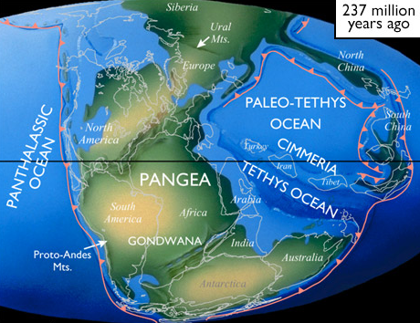
In my previous post entitled Roxbury Conglomerate Part I, I discussed the tectonics that brought the volcanic island-chain of Avalonia to present-day New England from its austral location. Avalonia rifted from the ancient African coast of northern Gondwana, when the rocks of the Boston Basin and the Roxbury Conglomerate were formed. Avalonia then drifted across the Iapetus Ocean with its closure, docked with Laurentia, and was incorporated within Pangaea, the Permian supercontinent. When Pangaea finally rifted apart, Avalonia assumed a coastal, Atlantic-configuration in New England, referred to as the terrane of the Southeastern New England Avalon Zone. The Avalonian lithotectonic belt and adjacent peri-Gondwanan terranes contributed to the landmasses of neighboring regions of Laurentia, and western Europe and Africa across the Atlantic.

THE GEOLOGIC FRAMEWORK OF THE BOSTON BASIN
The bedrock formation of the Boston Basin extends well beyond the limits of Boston, underlying part or all of Roxbury, Quincy, Canton, Milton, Dorchester, Dedham, Jamaica Plain, Brighton, Brookline, Newton, Needham, and Dover. The Boston Bay Group is preserved within the Boston Basin. It consists of clastic sediments and interbedded, mafic volcanics which record a Late Proterozoic rifting or back-arc spreading event related to its formation during its departure from Gondwana. The Boston Bay Group’s sedimentary rocks were derived from high in the volcanic highlands of Avalonia and deposited by rivers including those from a glacial source. These highly eroded sedimentary and volcanic remnants can be found in and around the basin, but a challenge to identify in the heavily populated, paved-over, densely vegetated, and glacially scoured landscape of Greater Boston.

This map depicts the bedrock of the Boston Basin
and that of the neighboring volcanic and metamorphic zones of Avalonia.
Abbreviations for the Roxbury Conglomerate (Proterozoic Z to earliest Paleozoic) are colored tan:
PzZc, Cambridge Argillite; PzZrb, Melaphyre in Roxbury Conglomerate. 
Modified from the Bedrock Geologic Map of Massachusetts, Department of the Interior,
United States Geological Survey, Goldsmith et al, 1983.


This schematic map illustrates the cross-sectional relationship of the Boston Basin (tan) 
to the adjacent volcanic and metamorphic zones of Avalonia.
Modified from the Bedrock Geologic Map of Massachusetts, Department of the Interior,
United States Geological Survey, Goldsmith et al, 1983.


The Southeastern New England Avalon Zone’s magmatic rocks record plutonism and volcanism (ca. 625-590 Ma) and intrusive activity with the Dedham granite (ca. 610 Ma) and the Westwood Granite (ca. 599 Ma). These plutonic and volcanic rocks are overlain in the Boston Basin by sedimentary rocks of the Boston Bay Group, namely the Roxbury Conglomerate, which dominates the southern part of the basin, and above it, the shale or mudstone of the Cambridge Argillite (or Cambridge Slate), which dominates the northern part of the basin.  Late Neoproterozoic volcanoclastic sediments (ca. 596 Ma) include the Lynn Volcanic Complex to the north of Boston and the Mattapan Volcanic Complex to the south. They record arc magmatism in the Avalonian terrane of southeastern New England (Avalonian dates and information from M.D. Thompson et al, Neoproterozoic Paleography of the Southeastern New England Avalon Zone, 2007).


Schematic map of the Southeastern New England Avalon Zone around Boston.
From Thompson et al (Neoproterozoic Paleography…, 2007).

This diagram is an interpretive Neoproterozoic-Early Paleozoic tectonostratigraphic column of Avalonian rocks in southeastern New England. Note the “Volcanic Arc Basin” phase illustrating the deposition of the Boston Bay Group’s Roxbury Conglomerate and the Cambridge Argillite, and its overlying association with the Brighton volcanics. Modified from Nance et al, 1991.

The final brush strokes were painted onto the ancient landscape of the basin by glacial erosion which conferred to the region the characteristic topography of an outwash plain. Those strokes served to over-print the subdued paleotopography of the existing rift basin. During the Pleistocene Epoch, the Laurentide ice sheet was the last continental glacier to advance across New England. The erosional and depositional processes of this ice sheet formed most of the present day surficial geology of the region including the basin.

A CONGLOMERATE BY ANY OTHER NAME
When pebbles, cobbles, and boulders accumulate and are cemented within a finer-grained matrix, the resultant rock is called conglomerate or puddingstone, and the rock fragments are called clasts. The term puddingstone appears to be a more frequent terminology in both England and New England. Conglomerates accumulate in a variety of environments and usually indicate the existence of steep slopes or very turbulent currents. These environments may include energetic mountain streams, strong wave activity along a rapidly eroding coast, and even glacial and landslide deposits. The clasts are valuable in identifying the source areas of the sediments, and therein provide clues to their history. Clasts that travel a considerable distance tend to become rounded. U-Pb detrital zircon geochronology can be used to date the formation of the clasts and delineate the source rock based upon its geochemical signature.

THE LITHOLOGY OF THE ROXBURY CONGLOMERATE
The type locality for the Roxbury Conglomerate is the town of Roxbury, Massachusetts, a neighborhood of Boston situated to the southwest. Roxbury was founded by English colonists in 1630 as an independent community before its annexation to Boston. The town had many resources for the early colonists amongst which were stone for building. In fact the town was originally called “Rocksbury” because of the many outcrops of native Roxbury puddingstone. Its puddingstone was described by the Boston physician and author Oliver Wendell Holmes, Sr. (his Jr. son was the Supreme Court justice) in The Dorchester Giant as “plums in a pudding.”

Traditionally, Roxbury Conglomerate is divided in ascending order into the Brookline, Dorchester and Squantum Members (geochronologically constrained as younger than ca. 593 Ma). Although lithologically variable, the conglomerate can be summarized as having sediment that is poorly sorted and ranging in size from fine sand to coarse cobbles. The matrix variably consists of grayish-pink, feldspar-rich, arkosic sandstone. Clast types generally include a mix of igneous and metamorphic rock such as granite, rhyolite, quartzite and felsic rock derived from the surrounding volcanic highlands. Each rock type has its own distinctive history such as speckled granite formed by the underground cooling of magma, and maroon and pink rhyolite formed during volcanic eruptions. The clasts range in color from light blue-gray to dark gray, and pale pink to maroon.


Clasts vary in size from small pebbles to boulders almost a foot in diameter such as this one.


This small puddingstone ledge in Brookline possesses a WNW-trending dip.
The implication of bedding is suggested in this exposure but may represent cleavage dipping.
In front of the Museum of Science in Boston is a large display of rocks from all over the world, including New England. On display is a massive boulder of Roxbury Conglomerate with one side beautifully polished. Here one can see the density of the clasts as well as their varied composition. I was able to differentiate four or five clast-types embedded in the matrix. It's worth a trip to the museum to check it out.

There remains some controversy surrounding the precise origins of the Roxbury Conglomerate and its members, and the Boston Bay Group as a whole, many of which are attributable to facies interpretations, dating, and deciphering the intricacies of tectonic origins. For example, the message that has been evolving over the years is that not all the conglomerate within the Boston Basin can be lumped together, as has been traditionally done, into a single “Roxbury” Conglomerate. The conglomerate in the “Brookline-Roxbury” belt is probably younger, but has not been dated. In addition, the Squantum Member was originally interpreted as a glacial till, but now is generally viewed as a submarine debris flow deposit with a probable glacial influence. Some researchers have linked the diamictites and mudstones of the Squantum succession with a “Snowball Earth” event rather than a meltwater-dominated alpine glaciation or small local ice caps (M.D. Thompson et al, A Roxbury Review).

PUDDINGSTONE AS A BUILDING MATERIAL
Typically, conglomerate is a rather coarse, irregular and somewhat friable material as a building stone, especially in comparison to granite, which later gained prominence in its use in Boston. This can make conglomerate unsuitable for architectural use. However, the firmly-cemented and relatively high compressive strength of the local puddingstone in Boston was the exception. In addition, the stone is impervious to moisture and resistant to New England’s frost and harsh winters. Over time, the rock has not been observed to crack, scale, crush or disintegrate, and the color of the seam-faces remains stable. Its coarse and pebbly texture, however, makes it difficult to satisfactorily “dress” the exposed surfaces of the stones. Subsequently, the puddingstone was sculpted into blocks (called ashlar masonry) with the exposed facade-surfaces left somewhat coarse. Field walls, however, were often constructed by stone masons from irregularly shaped stones (called rubble masonry).

Joint faces of structures built with puddingstone are generally well-oxidized or iron-stained, and develop a warm and permanent brown color richly mottled in many tints. This encouraged the usage of the material with a natural, rough-hewn finish, but limited its use to facade-surfaces rather than on difficult-to-finish corners. Consequently, stone such as granite was employed for the corners (called quoins after the French word for corners), and the dressing of apertures and trimmings. Granite also contributed a load-bearing advantage to structures.


Gasson Hall of Boston College is typically constructed of granite on the corners
and Roxbury Conglomerate on the facade.

 PUDDINGSTONE QUARRIES AND THE STRUCTURES BUILT IN AND AROUND BOSTON
Between the Boston Basin and the Blue Hills south of Boston lies the conglomerate-zone, extending from Newton, through Brighton and Brookline to Dedham and Dorchester, generally to the west and south of Boston. The conglomerate forms the bedrock in the region, save glacial outwash and till that overprints the region. Roxbury Conglomerate can be seen outcropping in countless ledges and small cliffs, a few of which were developed into quarries. A principal quarry was developed on the north side of Parker Hill in Roxbury, while other exposed ledges were used in a belt that extended to the southeast. Smaller quarries also existed in Brighton and Newton, towns to the west of Boston, which supplied puddingstone locally. Boston’s puddingstone quarries were all conveniently located to building sites, considering that proximity was an important factor in transporting the stone by horse, oxen and wagon.

 
This is a map of the bedrock geology of the city of Boston. Note the distribution of the Roxbury Conglomerate within the basin especially in the towns of Boston, Roxbury, Jamaica Plain, Dorchester. Large exposures also exist in Newton and Brookline. Modified from http://www.cityofboston.gov/parks/pdfs/os7amaps1.pdf

Initially, puddingstone found its way into numerous house foundations in the vicinity of the quarries. Eventually, over 35 Victorian Gothic churches were built with it in the 19th and the early 20th centuries, making it the de facto “church-stone” of Boston. The black and tan colors of the conglomerate seemed appropriate for the Gothic style in the ecclesiastic architecture of the time. It was also used in public structures, lodges, bell towers, stables, walls and landscape architecture (e.g. arches, bridges, steps, retaining walls, etc.), in Boston, Roxbury, Brighton, Brookline and Newton.

A major puddingstone contributor was Timothy McCarthy’s seven-acre quarry on the slopes of Parker Hill in Roxbury (now Boston) in the neighborhood of Mission Hill. An Irish stonemason, McCarthy operated the quarry for building stone from around 1864 to 1910. Stone masons found the rock relatively easy to cut, extract and shape, compared to granite. The demise of the quarry began at the turn of the century, when housing construction encroached upon the quarry. In addition, concrete was increasingly replacing stone foundations, while churches of the Classical Revival Period preferred lighter-colored limestone and marble rather than gloomy conglomerate, which was being used more for crushed stone on roads and street car beds. McCarthy’s Parker Hill quarry was backfilled in 1960.


The city of Boston has been built up all around the remaining ledgy remnants
of McCarthy’s Parker Hill quarry, which can be seen today adjacent to a parking lot behind One Brigham Circle, a shopping complex in the Mission Hill neighborhood of Boston. The area above the quarry has been preserved as Puddingstone Park for community recreation.          

Puddingstone Park is dotted with instructive signs describing the geologic origins of the puddingstone. Professor Emerita Margaret Thompson of Welleseley College, a professor, geologist and researcher in the tectonics and dating of Avalonia, contributed the text for the signs.


The Basilica of Our Lady of Perpetual Help (1878) towers above McCarthy’s quarry and Puddingstone
Park in the foreground. The church rose from the very rocks it contained. Looking east and also within the Boston Basin but nearly at sea level, the Back Bay region of Boston can be seen in the distance to the left of the basilica.


This view of the Basilica of Our Lady of Perpetual Help (1878), referred to as “The Mission Church”,
is across the street from McCarthy’s quarry.


Here is another relict puddingstone quarry at the base of Peters Hill, a tall drumlin at the Arnold Arboretum in Boston. The outcrops are generally diamictite, assigned to the Squantum Member at the top of the Roxbury Conglomerate, based on its clast-angularity, poor sorting and matrix-supported character.


This is the Dudley Cliffs in Roxbury directly across from Madison Park High School,
another ledge that was used to supply puddingstone for construction

Tremont Street Methodist Church in Roxbury was the first church built of puddingstone in 1862.

The Church of the Covenant (1865) in fashionable Back Bay was originally the Central Congregational Church in Boston. It was redecorated with Tiffany stained-glass windows and mosaics. Oliver Wendell Holmes said: "We have one steeple in Boston that to my eyes seems absolutely perfect, that of the Central Church on the corner of Newbury and Berkeley Streets."


A closer look at the ornate steeple referred to by Holmes

The Old South Church in the Back Bay of Boston was built in the style
of Northern Italian Gothic Architecture, replete with campanile (1865).
It’s also known as the “Church of the Finish Line of the Boston Marathon”

Roxbury Presbyterian Church (1891)

The bell tower and spires of Gasson Hall, Boston College in Newton (Chestnut Hill) were designed
by the architect Charles Donagh Maginnis in 1913. He is considered the Father of American Gothic Architecture with many other colleges drawing from his design. Typically, the construction
illustrates the use of local conglomerate on the facade and granite on the corners.

The Church of the Redeemer in Newton (1915) was designed by Henry Vaughan,
architect of the National Cathedral in Washington, D.C.

A fine example of a lovely young lady, and an arch and wall
composed of puddingstone on the Boston College campus.

IN CONCLUSION
With its coarsely-ornamental appearance, high availability, suitable working characteristics, favorable physical properties and convenience of location, Roxbury Conglomerate found its way into usage in early house-foundations, Gothic churches, and landscape architecture in Boston and its immediate environs to the west and south. Those structures are unmistakable and can be seen today preserved in their stately splendor.

In talking to local Bostonians, it's surprising how many are familiar with the term puddingstone, but relatively few are aware of its architectural heritage, let alone its astounding geological provenance. Hopefully, this post will help shed more light onto the Roxbury Conglomerate, the state rock of Massachusetts.

Also, check out David Williams' blog and book for all the great geology you can discover on the urban landscape in Boston and other cities at http://stories-in-stone.blogspot.com/


Sunday, March 13, 2011

Architectural Geology of Boston: The Roxbury Conglomerate (Puddingstone) Part I – The Tectonic Evolution and Journey of Avalonia


Dear readers and followers,
Google Blogger somehow corrupted this post making it unreadable by omitting words, phrases and even entire paragraphs. I'm in the process of re-creating the post. Please check back...almost done! Sorry for the inconvenience.
Doctor Jack


"I wonder whether the boys who live in Roxbury and Dorchester are ever moved to tears or filled with silent awe as they look upon the rocks and fragments of "puddingstone" abounding abounding in these localities... Yet a lump of puddingstone is a thing to look at, to think about, to study over, to dream upon, to go crazy with, to beat one's brains out against. Look at that pebble in it. From what cliff was it broken? On what beach rolled by the waves of what ocean? How and when embedded in soft ooze, which itself became stone, and by-and-by was lifted into bald summits and steep cliffs, such as you may seen on Meetinghouse-Hill any day-yes, and mark the scratches on their faces left when the boulder-carrying glaciers planed the surface of the continent with such rough tools that the storms have not worn the marks out of it with all the polishing of ever so many thousand years?"
The Professor at the Breakfast Table, Oliver Wendell Holmes, Sr., 1964


The Roxbury Conglomerate displaying its sandstone matrix and variously-derived clasts

When I first moved to Massachusetts many years ago, I didn't know the first thing about geology. I had certainly heard of plate tectonics but didn't really understand it or knew nothing of its relevance. I never learned a thing about it in high school back in the 60's. Tectonics was barely in its infancy when I graduated. Now living in a western suburb of Boston, I was intrigued by the composition of the stone wall in my yard. In fact, all the walls in town looked the same. They were made of a sandy-textured stone with big, round rocks stuck in it. I read that it was called puddingstone and that it traveled a long distance to arrive here. That was the beginning of my geological journey, that wall. This post (and the one that follows), in fact my entire blog, is the result of that enlightenment.

THE STATE ROCK
The Roxbury Conglomerate is the state rock of Massachusetts, named as such in 1983. It forms much of the basement rock under the city of Boston and its surrounding environs. What's more, a great many of the older structures in Boston are constructed of it! What is the Roxbury Conglomerate? How did it form? When did it form? Why was it used as a building stone as opposed to other rocks that were more plentiful and more massive in New England? Much is known, but in spite of investigation and research that has spanned over a century, the depositional and tectonic history of the Roxbury Conglomerate and the Boston Basin, in which it is found, has remain somewhat controversial and enigmatic.

COMING TO TERMS
Geologists are partial to changing the names of large landmasses (also called cratons) and bodies of water in order to denote a change in the time frame, a potentially confusing situation for the layman (and even amateur geologist) but necessary nonetheless. Understanding such changes in nomenclature is relevant to our discussion in this post and in reading the literature. So, here's my attempt at a simplistic explanation.

The Earth's tectonic plates have been rearranging the continents and oceans like pieces of an enormous jigsaw puzzle for many millions of years, actually billions. A continental landmass that existed during the Cambrian Period undoubtedly would have drifted to another location during say the later Permian Period. The system of nomenclature provides for the naming of a landmass during one time and location, and allows for a uniquely different name for the landmass during a different time and location. In that way, the name of the landmass automatically conveys a general time-frame and implies a specific relationship to other landmasses and bodies of water. It's that simple.

For example, North America is often referred to as proto-North America to indicate the continental landmass that existed any time before the modern one, obviously a very broad sense of time. More specifically, Laurentia refers to proto-North America during the early Paleozoic. During that time frame, as we shall see, the smaller terrane of Avalonia and Baltica (a micro-continent that eventually formed parts of  Europe, Scandinavia and Siberia) collided with Laurentia. That formed Laurussia (or proto-North America) during the Middle Paleozoic. Laurussia, in older, pre-tectonic terminology, is also referred to as the Old Red Sandstone continent during the Devonian. Laurasia is often used interchangeably in the literature for Laurussia (technically includes the additional accretion to Laurussia of the landmasses of Siberia, Kazakhstania, and the North China and East China cratons). During the late Paleozoic, the continent of Gondwana collided with Laurussia, and that formed the massive supercontinent of Pangaea, yet another proto-North America. Pangaea ultimately drifted apart during most of the Mesozoic, leaving Laurussia to become the modern continent of North America and all the remaining continents to be dispersed throughout the globe. You can follow the name changes on the various maps below taking note of their time frames.

By the way, we use the same concepts of nomenclature for bodies of water. The Iapetus Ocean (often called the proto-Atlantic Ocean) and Rheic Oceans that existed between Gondwana and Laurentia were consumed when Pangaea formed, only to give birth to its oceanic successor, the Atlantic Ocean, when Pangaea finally rifted apart. To quote the famous Scottish geologist John Hutton, "we find no vestige of a beginning, no prospect of an end." 

THE EVOLUTION OF AVALONIA AND ITS JOURNEY ACROSS THE IAPETUS
In order to fully appreciate the origin and geologic history of the Roxbury Conglomerate let's examine the global "big picture" for the last billion years. In particular, let's trace the path that Avalonia assumed during its inception as a juvenile magmatic-arc, its accretion to, and subsequent drifting from the northern margin of Gondwana, it stectonic journey across the Iapetus Ocean, and its collision with eastern Laurentia. For, it is juvenile Avalonia where the Roxbury Conglomerate was deposited. Note that there is not universal acceptance amongst geologists regarding the timing and tectonic provenance of Avalonia's history.

Durng the late Precambrian (Neoproterozoic ca. 1100 Ma), a massive supercontinent commonly referred to as Rodinia formed and broke up (ca. 800 to 700 Ma). The timing of break-up and the exact fit of its elements remain sonewhat controversial. Regardless, Rodinia's rifting apart eventually spawned two smaller supercontinent siblings called Laurentia and Gondwana (also Gondwanaland). Gondwana included most of the continental landmasses in today's Southern Hemisphere. Proto-Avalonia (during the Proterozoic) has been suggested to possibly have a peri-Rodinian, island-arc provenance in spite of the fact that undisputed basement upon which it developed is nowhere, unequivocally exposed (with the exception of peri-Gondwanan terrane called Tregor-La Hague in northern France dated ~2 Ga). Regardless, the origin of the proto-Avalonian terrane remains controversial.

ANCIENT RODINIA RIFTS APART SPAWNING LAURENTIA AND GONDWANA
These Mollweide Projections look at the Earth as a flat map. They accurately depict area at the sacrifice of angle and shape. This map is an interpretive illustration of the supercontinent of Rodinia after its breakup in the Late Precambrian (Neoproterozoic). Its rifted-remnants became the somewhat smaller continents of Laurentia and Gonwana. Laurentia eventually formed most of North America. Gondwana was an amalgamation of the modern continents of South America, Africa, India, Australia and Antarctica.


Modified from Ron Blakey and Colorado Plateau Geosystems, Inc.

AVALONIA RIFTS FROM GONDWANA
Rodinia has rifted into the two aforementioned major landmasses. The Iapetus Ocean separates equatorially-located Laurentia from australly-located Gondwana. In the Middle Cambrian, the juvenile, island-arc terrane of Avalonia (shown as "new England and Nova Scotia" on the map) rifted from the northern margin of Gondwana. Thus began a tectonic journey that would transport Avalonia across the closing Iapetus Ocean and culminate with its collision with Laurentia. Located within the terrane of Avalonia, the foundation on which the city of Boston was built formed from the Neoproterozoic rocks that originated in the mid- to high-latitudes region of the Southern Hemisphere. 

SOUTH POLAR VIEW
This south polar perspective  during the Early Ordovician, Avalonia (labelled as such) is beginning to rift from Gondwana and will then initiate a trajectory across the Iapetus Ocean, along with Baltica, towards Laurentia. Equatorially-located Laurentia (far left) awaits their collision. 


AVALONIA BEGINS A TECTONIC JOURNEY ACROSS THE IAPETUS
During the Late Ordovician, Avalonia rifted from Gondwana, which spans the South Pole to north of the equator (seen off to the right). Along with Baltica (which formed Scandinavia and parts of northern Europe), the two landmasses drifted towards Laurentia, as the Iapteus Ocean closed. The rifting of Avalonia from Gondwana occurred diachronously with the formation of the intervening Rheic Ocean, which will ultimately close during the formation of Pangaea. The basement rocks of the Boston Bay Group, including the Roxbury Conglomerate, have already formed on Avalonia and are now tectonically "travelling" with it. At about the Ordovician-Silurian boundary, while drifting in the Iapetus towards Laurentia, Avalonia amalgamated (a soft, oblique docking) with Baltica in equatorial paleolatitudes. That amalgamation consumed the intervening Tornquist Sea (see map). 


AVALONIA AND BALTICA ZERO-IN ON LAURENTIA
During the Middle Silurian, Avalonia and Baltica are about to collide with Laurentia, which will become Laurussia. The Iapetus Ocean is nearly consumed at the expense of the opening Rheic Ocean. Gondwana is growing near. It too will collide with Laurussia. After the consumption of the Iapetus Ocean with the collision of Avalonia and Baltica to Laurentia, a new ocean will form called the Atlantic with the rifting apart of Pangaea. In Greek mythology, Iapetus was the father of Atlantis.


THE ACADIAN-CALEDONIAN OROGENS
During the Early Devonian, the collision of Avalonia with Laurentia will initiate a major 
mountain-building event called the Acadian Orogeny in the proto-North America region. With the accretion of Baltica and Laurentia, the Caledonian Orogeny formed a geographically distinct orogenic belt in the proto-European region (Great Britain and Scandinavia) of the landmass. Laurentia will become Laurussia after its collison with Avalonia and Baltica. Closure of the Rheic Ocean was facilitated by subduction beneath the southern Baltican margin (Variscan belt); whereas, arc-magmatism developed on the previously accreted Avalonian terranes, and by southward subduction beneath the northwestern margin of Gondwana (Appalachian-Ouachita belt), where Laurentia forms the lower plate. The eventual collision of Gondwana with Laurussia (Mississippian) will consume the Rheic Ocean and form Pangaea by the end of the Permian.


GONDWANA'S LAURUSSIAN COLLISION FORMS PANGAEA
During the Late Triassic, with Gondwana having slammed into Laurussia, Avalonia has become internalized within Pangaea. The collision has initiated the Alleghenian-Herycnian/Variscan Orogeny, a major mountain-building event. Early rifting of Pangaea is initiating in the north. Note that both the Iapetus and Rheic Oceans  have long been consumed, leaving the Panthalassic Ocean as the major global body of water. The rifting of Pangaea began in the north during the Early to Middle Jurassic with the formation of the North Atlantic Ocean.


ALLEGHENIAN-HERCYNIAN/VARISCAN OROGENS
During the Pennsylvanian, the collision of Gondwana with Baltican Laurussia and the peri-Gondwanan terranes portion of Laurussia sequentially with its West African margin docking with southern Baltica and eastern Laurussia (Hercynian/Variscan Orogens in southern Europe and the Alleghenian Orogen in proto-North America); whereas, Gondwana's Amazonian margin collided with southern Laurussia (Ouachita Orogen). The resulting Variscan-Alleghenian-Ouachita belt was arguably the largest collisional orogen of the Paleozoic, and sutured Gondwana and Laurussia to form Pangaea.


RIFTED PANGAEA PLACES THE BOSTON BASIN IN COASTAL NEW ENGLAND
In the Late Cretaceous, Pangaea has rifted apart and the contemporary continents of the world have dispersed apart throughout the globe. Previously accreted Avalonia, now referred to as the Southeastern New England Avalon Zone, which includes the Boston Basin, has assumed a passive location on the coast of eastern North America. The majority of the eastern seaboard of present day North America was derived from similar but smaller peri-Gondwanan terranes (e.g. Ganderia, Carolinia, Meguma, etc.), some from an African and others from an Amazonian locale. A corollary to the breakup of Pangaea was the redistribution of early Paleozoic parts of Laurentia and Avalonia (giving rise to the terminology of West and East Avalonia) on either side of the North Atlantic, where we find them today. Therefore, in addition to New England and Atlantic Canada, Avalonia formed parts of southeastern Ireland, southern Britain, and a substantial area of Europe surrounding Belgium, after Pangaea rifted apart. 


THE BIRTH OF THE BOSTON BASIN